By: CATALYST
CATALYST has developed new, high-speed, orthorectification functions. The code takes advantage of modern, multi-core processor architecture, as well as NVIDIA’s Graphical Processing Units (GPUs), to process standard data products from the WorldView-1, QuickBird and IKONOS satellites […]
Read MoreBy: CATALYST
New computational environments are emerging – cloud computing which promises to provide vast computational resources on demand. Many corporations are moving to such environments to better share resources between compute-intensive applications, to provide for surges in […]
Read MoreBy: CATALYST
PCI Geomatics has overcome the challenges caused by the traditional raster image management methods with its enterprise solution: the Geomatica Image Management System (GIMS). With 25 years of experience in building image-centric geospatial solutions, PCI Geomatics […]
Read MoreBy: CATALYST
Every day, earth imaging satellites deliver large volumes of critical information about our natural resources, our cities, our transportation, our climate, and more. In a way that traditional maps cannot, these images provide detail and context […]
Read MoreBy: CATALYST
CATALYST has a full set of object-based image analysis (OBIA) tools that can be used to quickly and accurately extract impermeable land area on a per parcel basis. Imagery is segmented based on the shape and […]
Read MoreBy: CATALYST
Traditional methods for generating geo-information products from large quantities of remote sensing images are too often limited by production inefficiencies and long to-market cycles. PCI Geomatics’ enterprise solution to these challenges is a customizable, cost-effective GeoCapacity […]
Read MoreBy: CATALYST
This article describes how high-resolution satellite data can be used to extract accurate digital elevation model (DEM) for a mining application in the Amazon region. The resulting vertical accuracy can be within RMS error of 1.5m […]
Read MoreBy: CATALYST
This report details the performance of the new DEM extraction application for the CATALYST Enterprise system. The main logic of the application is based on the code in “genautodem.cpp”, which contains thecore functionality of the DEM […]
Read MoreBy: CATALYST
The United Nations Office on Drugs and Crime (UNODC) operates several projects that provide detection data to governments where illicit crops are grown including Colombia, Peru and Bolivia (for coca), Afghanistan, Laos, and Myanmar (for opium), […]
Read MoreBy: CATALYST
Leveraging CATALYST InSAR processing expertise, RADARSAT-2 imagery was processed to detect and derive displacement using natural targets and corner reflectos in Cold Lake, Alberta. Results: Using commercially available data such as RADARSAT-2 and TerraSAR-X, Geomatica InSAR […]
Read MoreBy: CATALYST
Earth Data, Simplified The Earth’s surface is constantly changing. Waves, wind, water and ice reshape our lands through erosion, and earthquakes – large or small – cause ground displacement around the world. But it’s not just […]
Read MoreBy: CATALYST
Manual GCP and tie point collection were wasting valuable man-hours and creating inaccurate results. A new solution with ArcGIS 10 integration was required. PCI Geomatics’ GeoImaging Tools software seamlessly integrates data from multiple sources into any ArcGIS […]
Read MoreBy: CATALYST
To identify stressed vegetation in the most cost-effective way possible, high-resolution satellite data can be purchased in areas covering the fields in question. Five-meter resolution RapidEye imagery is ideal to investigate identified areas of crop stress […]
Read MoreBy: CATALYST
Sea ice can be difficult to study because of the remote and hazardous locations in which is exists. Remotely sensed SAR data is one half of the equation. To complete the analysis, SAR processing software with the […]
Read MoreBy: CATALYST
The Perenco Group utilizes CATALYST Professional Software to help them identify and analyze surface lineaments to streamline their exploration efforts Results: A nation-wide orthorectification of 10,000 images that now takes three days will be finished in […]
Read MoreBy: CATALYST
The Geological Survey of Norway makes use of Catalyst’s new GeoImaging Tools for ArcGIS to reduce the cost of mapping the bedrock in the Rogaland region of Norway. Results: Catalyst’s GeoImaging Tools provides ArcGIS users with […]
Read MoreBy: CATALYST
Catalyst’s Historical Airphoto Correction workflow was designed to consider the various problems that are often encountered with historical imagery. Several factors make historical airphotos more difficult to process than standard airphotos, which include: Results: Catalyst developed […]
Read MoreBy: CATALYST
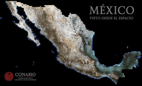
The RapidEye constellation makes it possible to collect massive amounts of imagery, which is critical to ensure cloud free images are available for analysis. This graphic depicts the archives available over Mexico for 2014 – imagery […]
Read MoreBy: CATALYST
The Historical Airphoto System (HAP) system offers an automatic approach consisting of three main processing steps (Data Ingest, Coarse Alignment and Fine Alignment). Ingested imagery are provided approximate positioning that is further improved through the collection […]
Read MoreBy: CATALYST
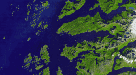
Glacier Bay National Park and Preserve, located on the South Eastern Alaska coastline, is home to spectacular glaciers and ice fields. The park is designated as a UNESCO World Heritage Site due to its glaciers and […]
Read More