Earth Data, Simplified
The Earth’s surface is constantly changing. Waves, wind, water and ice reshape our lands through erosion, and earthquakes – large or small – cause ground displacement around the world. But it’s not just natural forces that can cause change. Human activities, like groundwater consumption, construction and mining operations, are causing cities, towns and our critical infrastructure to sink and rise.
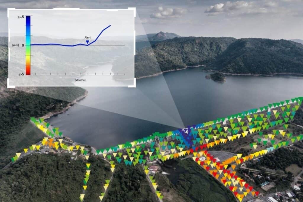
These changes are tiny, on the scale of millimeters or centimeters per year, but sometimes that’s all that’s needed to cause instability in an area. So how can we mitigate catastrophic failures of structures like tailings dams and bridges? Or take preventative action to ensure sinkholes or unexpected movement don’t impact infrastructure or cause loss of life?
It’s all linked back to ground displacement monitoring.
CATALYST and Amazon Web Services for Risk Assessment
CATALYST, a PCI Geomatics brand, is collaborating with Amazon Web Services (AWS) to provide ground displacement monitoring to users through AWS Data Exchange (ADX). These feeds are derived from satellite-based Earth Observation (EO) intelligence, and monitoring is shown as a visual data feed down to the millimeter scale.
“This is a risk mitigation solution for industries with business application. It allows you to monitor infrastructure or land from the sky and see when there’s been ground displacement above or below normal levels. Once you’re aware of it you can mitigate the associated risk.”
June McAlarey, President and CEO of PCI Geomatics.
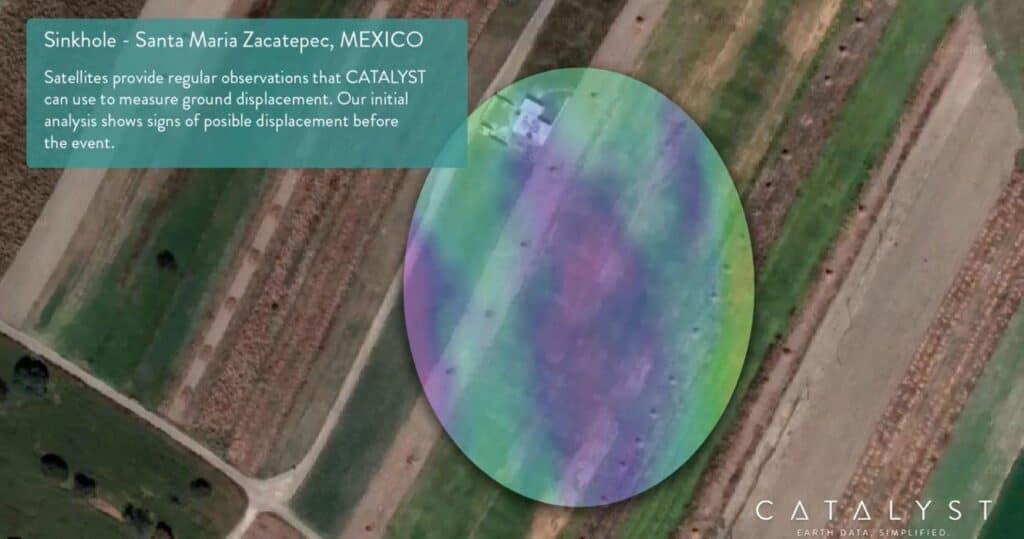
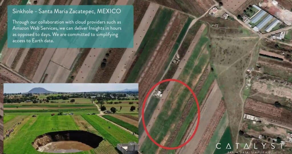
Often there are warning signs shown in the ground before catastrophic events happen. For example, possible ground displacement was shown before a 60-meter large sinkhole appeared in rural farmland in Santa Maria Zacatepec, Mexico. Luckily, the family who lived in the farmhouse adjacent to the sinkhole was evacuated so it caused minimal damage. But if this had taken place in a suburban area, the consequences could have been much worse.
CATALYST and Amazon Web Services for Risk Assessment
One of the benefits of this collaboration is that Amazon already has global reach. That means this solution is accessible to everyone through their API.
“What we’ve built is agnostic and interoperable. Through the API you can effectively plug and play; you can consume the data feed any way you like. You can easily connect your workflows and choose where you want to visualise the feed. It really allows people like me, who aren’t geospatial technical specialists, to go in, pick an area, and visualise it within my own workflows, to answer the questions I have. What we’re trying to do is democratise geospatial data for all, by bringing the science to the data - instead of the other way around.”
June McAlarey, President and CEO of PCI Geomatics.
This interoperability means new users won’t need to overhaul their processes to start using satellite Earth Observation data for ground monitoring. They can simply integrate it into their existing Emergency Management or Risk Management systems.
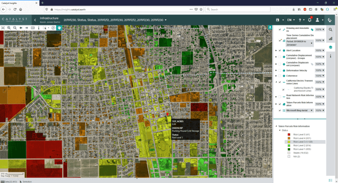
The data feed can also be paired with the CATALYST Insights webapp which has a simple and intuitive interface. This means anyone, not just those familiar with geospatial data can view ground displacement risk in their areas of interest.
“We’re excited to be collaborating with Amazon, as we believe this new offering is very disruptive - and Amazon is a proponent of creative, innovative endeavours. But this is also just the first step - we plan to expand to other cloud providers in the future, to give our users even more flexibility.”
June McAlarey, President and CEO of PCI Geomatics.
Providing Accessible Ground Displacement Data for All
Traditionally, ground displacement monitoring is done through sensor-based technology using land surveys. This is expensive to do, and because of that, monitoring may only happen a few times a year – leaving gaps of time where ground displacement is not being observed at all. Moreover, because of the expense only some parts of the area of interest may be surveyed – leaving some areas completely unmonitored.
“We’re providing an easy to consume satellite data solution, with regular monitoring and guaranteed revisit and coverage over large areas. We believe it’s going to turn a lot of industries on their head. It’s inexpensive and means you can monitor your ground displacement from anywhere in the world, at any time. It will make a huge difference to industries like mining, where they have to fly a crew out to a remote location to survey a tailings pond, for example. That can cost tens of thousands of dollars per trip. And it doesn’t have to be one or the other, you can supplement your ground-based monitoring with satellite monitoring. By saving costs, this means you can allocate those resources where and when they are needed to minimise risk. So you could reduce the frequency of ground surveys, or increase them in areas that could cause a risk to operations.”
June McAlarey, President and CEO of PCI Geomatics.
As well, this solution means companies don’t need to have a geospatial expert on hand, to get the information they need. Our team of InSAR experts and specialists ensure parameters are correctly tuned for all projects. The displacement measurements undergo rigorous quality control before delivery.
“We’re working with a construction firm who wants to understand ground displacement measurements around their project. But it was a significant barrier for them to hire a geospatial consultant to leverage satellite data.“
June McAlarey, President and CEO of PCI Geomatics.
Instead, the company is able to get the satellite data insights they need through the CATALYST/ ADX data feed – saving them both time and money. And not needing to have a geospatial expert on hand can have further reaching impacts than just saving time and money – it can also help entire communities.
“We spoke to an indigenous community that’s surrounded by mines that are being slowly decommissioned. They can use our solution to monitor the tailings in the area and any other impacts on their land. This supports transparency between the mining companies and the communities they work in and helps ensure long-term satisfaction for both groups.”
June McAlarey, President and CEO of PCI Geomatics.
Providing Better Outcomes for Future Generations
The possibilities for Earth Observation cloud-based applications are endless.
There are so many use cases for this science, aside from just ground displacement. You could use it to count trees or crop size for agricultural management or calculate solar panel coverage in an area to see what the energy output may be. We will introduce these applications in the future.”
June McAlarey, President and CEO of PCI Geomatics.
For June, it all leads back to helping businesses and individuals make better decisions, faster.
The passion comes from seeing how we can break out of the box and create new applications for Earth Observation data. At the end of the day, we want to support better, sustainable outcomes for generations to come. If we can prevent man-made or natural disasters and avoid loss of life, how can you put a price on that? It all comes down to risk management and mitigation.
June McAlarey, President and CEO of PCI Geomatics.
To learn more about the Catalyst and AWS collaboration, visit our website.