
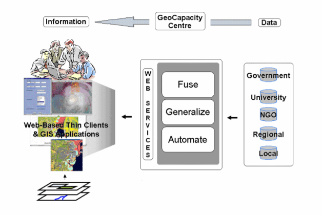
Traditional methods for generating geo-information products from large quantities of remote sensing images are too often limited by production inefficiencies and long to-market cycles. PCI Geomatics’ enterprise solution to these challenges is a customizable, cost-effective GeoCapacity Information System (GCIS) powered by automation technology aimed at large-scale, production-oriented geo-information creation – helping users make intelligent business decisions.

Results:
Increasingly, geo-information products based on large quantities of remote sensing images need to be generated cheaper, faster, and better. In response to this geo-spatial market demand, PCI Geomatics has developed a GeoCapacity Information System enterprise solution powered by open, standards-based, and easy-to-scale automation technology aimed at largescale, production-oriented, geo-information creation – helping your organization make intelligent business decisions.
GCIS enterprise
PCI’s Professional Services department can work with a client to produce an automated GCIS specifically tailored to your spatial information production. Designed for the client’s specific requirements, these solutions are built upon a flexible and standards-based architecture. With a commitment to open standards and interoperability, customized systems can incorporate PCI’s Geomatica Webserver technology, imaging and mapping programs, and interface with third party software applications.
About Catalyst
CATALYST is a PCI Geomatics brand, which has been introduced to put our leading edge technology into the hands of decision makers. We’re a startup – with hundreds of algorithms, scalable solutions, and decades of experience.
- Customized training - Application consulting - Implementation services - Product customization - Development of custom workflows - Knowledge transfer - Geomatics value-added consulting - Project scoping and management
PCI Geomatics value-added services extend GCIS technology through: