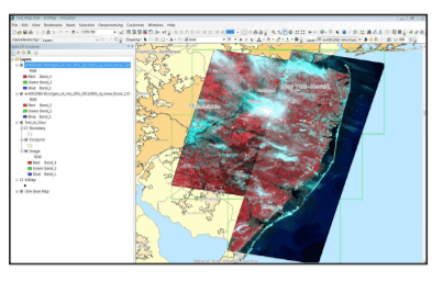
Manual GCP and tie point collection were wasting valuable man-hours and creating inaccurate results. A new solution with ArcGIS 10 integration was required. PCI Geomatics’ GeoImaging Tools software seamlessly integrates data from multiple sources into any ArcGIS workflow quickly and accurately.

Results:
What the SC Air National Guard used to measure in weeks and months can now be accomplished in hours; saving critical time and effort.
SCANG
Master Sgt Wilkerson contacted PCI for some assistance in trying to integrate SPOT-4 with his existing ArcGIS workflow. He wanted his SPOT-4 and SPOT-5 data to be accessible within a mosaic dataset in ArcGIS. GeoImaging Tools is fully customizable since the software is part of the ArcGIS Geoprocessing framework.
About Catalyst
CATALYST is a PCI Geomatics brand, which has been introduced to put our leading edge technology into the hands of decision makers. We’re a startup – with hundreds of algorithms, scalable solutions, and decades of experience.

The PCI GeoImaging Tools extension for ArcGIS has saved us multiple person hours of processing time. This has given us the ability to provide imagery to a multitude of Federal, DoD, State, and Civil authorities that are responding to disasters such as Tornadoes, Hurricanes, Earthquakes, Floods, and Wildfires. Time is the key. We are providing imagery to customers hours earlier than we could before using PCI’s tools.
Master Sgt Wilkerson
