By: CATALYST
Wetlands play a key role in regional and global environments and are critically linked to major issues such as climate change, water quality, the hydrological and carbon cycles, and wildlife habitat and biodiversity. Their existence is […]
Read MoreBy: CATALYST
What is our country’s estimated crop yield this year? How much food will we need to import? Will we have enough water for our nation’s needs? How can we expect our cities to expand? What new […]
Read MoreBy: CATALYST
The need for airphoto processing in resource, security, planning and other applications is continually increasing. How can these demands be met? Large scale projects require fast, efficient processing of thousands of images every year, providing critical […]
Read MoreBy: CATALYST
An Empirical Line Model (ELM) was tested to correct Sentinel-2A (MSI) images acquired in the tropical archipelago of San Andrés, Colombia. This approach uses a linear regression to model the relationship between the average ground reflectance […]
Read MoreBy: CATALYST
Geometric Correction of historical imagery is a complicated, time consuming and expensive operation. Due to a lack of development related to streamlining these operations, a significant amount of manual processing time must be invested into current […]
Read MoreBy: CATALYST
After demonstrating the exceptional performance improvement in the orthorectification module (approximately fourteen-fold – see CATALYST Enterprise Ortho Performance Whitepaper), the same approach has been applied to the pansharp module by taking advantage of newly developed code, […]
Read MoreBy: CATALYST
CATALYST has developed new, high-speed, orthorectification functions. The code takes advantage of modern, multi-core processor architecture, as well as NVIDIA’s Graphical Processing Units (GPUs), to process standard data products from the WorldView-1, QuickBird and IKONOS satellites […]
Read MoreBy: CATALYST
New computational environments are emerging – cloud computing which promises to provide vast computational resources on demand. Many corporations are moving to such environments to better share resources between compute-intensive applications, to provide for surges in […]
Read MoreBy: CATALYST
PCI Geomatics has overcome the challenges caused by the traditional raster image management methods with its enterprise solution: the Geomatica Image Management System (GIMS). With 25 years of experience in building image-centric geospatial solutions, PCI Geomatics […]
Read MoreBy: CATALYST
Every day, earth imaging satellites deliver large volumes of critical information about our natural resources, our cities, our transportation, our climate, and more. In a way that traditional maps cannot, these images provide detail and context […]
Read MoreBy: CATALYST
CATALYST has a full set of object-based image analysis (OBIA) tools that can be used to quickly and accurately extract impermeable land area on a per parcel basis. Imagery is segmented based on the shape and […]
Read MoreBy: CATALYST
This report details the performance of the new DEM extraction application for the CATALYST Enterprise system. The main logic of the application is based on the code in “genautodem.cpp”, which contains thecore functionality of the DEM […]
Read MoreBy: CATALYST
This article describes how high-resolution satellite data can be used to extract accurate digital elevation model (DEM) for a mining application in the Amazon region. The resulting vertical accuracy can be within RMS error of 1.5m […]
Read MoreBy: CATALYST
Traditional methods for generating geo-information products from large quantities of remote sensing images are too often limited by production inefficiencies and long to-market cycles. PCI Geomatics’ enterprise solution to these challenges is a customizable, cost-effective GeoCapacity […]
Read MoreBy: CATALYST
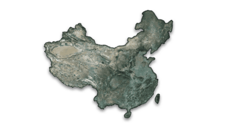
The United Nations Office on Drugs and Crime (UNODC) operates several projects that provide detection data to governments where illicit crops are grown including Colombia, Peru and Bolivia (for coca), Afghanistan, Laos, and Myanmar (for opium), […]
Read MoreBy: CATALYST
Leveraging CATALYST Enterprise’s rapid processing capability made it possible to optimize image selection from over 50,000 archive RapidEye images. Results: Using commercially available data such as RADARSAT-2 and TerraSAR-X, Geomatica InSAR is suitable for any land […]
Read MoreBy: CATALYST
Earth Data, Simplified The Earth’s surface is constantly changing. Waves, wind, water and ice reshape our lands through erosion, and earthquakes – large or small – cause ground displacement around the world. But it’s not just […]
Read MoreBy: CATALYST
Manual GCP and tie point collection were wasting valuable man-hours and creating inaccurate results. A new solution with ArcGIS 10 integration was required. PCI Geomatics’ GeoImaging Tools software seamlessly integrates data from multiple sources into any ArcGIS […]
Read MoreBy: CATALYST
Sea ice can be difficult to study because of the remote and hazardous locations in which is exists. Remotely sensed SAR data is one half of the equation. To complete the analysis, SAR processing software with the […]
Read MoreBy: CATALYST
To identify stressed vegetation in the most cost-effective way possible, high-resolution satellite data can be purchased in areas covering the fields in question. Five-meter resolution RapidEye imagery is ideal to investigate identified areas of crop stress […]
Read More