
How resolution, radar band, cost, archive depth and revisit frequency shape which SAR satellite fits your InSAR monitoring project
By Dr. Ben Conway-Jones, InSAR Specialist, CATALYST
Key Takeaways
- There is no single best satellite for InSAR. The right choice depends on your site's land cover, terrain, expected movement, timeline, and budget.
- Resolution sets how finely you can localize deformation: sub-metre commercial sensors suit individual structures, while open access data suits regional, wide-area monitoring.
- Radar band drives coherence: X-band suits urban areas and hard surfaces; C-band is the all-round midpoint, and L-band is often the only viable option over vegetation.
- Free Sentinel-1 data offers a global archive back to 2014. Commercial constellations offer higher resolution and on-demand tasking, but their archives vary by site.
- The sensor behind an InSAR analysis shapes how reliable your deformation record is. CATALYST’s sensor-agnostic workflow lets us combine free and commercial data in a “tip and cue” approach, and this guide explains the trade-offs so you can work with our team to find the approach that fits your site.
Interferometric synthetic aperture radar (InSAR) measures ground deformation by comparing the phase of repeat SAR images of the same area, detecting surface movement down to millimetre scale over large areas. For InSAR-based ground deformation monitoring, there are several SAR satellites to choose from, each one having unique features and considerations. Fortunately, CATALYST’s InSAR workflow is entirely sensor-agnostic, built on software compatible with data from 20+ SAR satellite constellations and has successfully processed and produced commercial-grade deformation data from all sensors discussed. This guide explains how CATALYST approaches sensor selection, the major differences between SAR satellites, and what those differences mean in practice for your project.
How Does Resolution Affect InSAR Monitoring?
Resolution determines how finely you can localize deformation. Each pixel in a SAR image records the average deformation within that pixel footprint, weighted by the strength of reflectors inside it. Commercial sensors such as TerraSAR-X, COSMO-SkyMed, ICEYE and Capella can resolve features at sub-metre resolution in spotlight modes. This level of detail is ideal for tracking movement on individual structures, quarry benches, or pipeline sections. Sentinel-1, by contrast, operates at approximately 20 m in its standard swath mode. One of the trade-offs is coverage: each Sentinel-1 acquisition spans a swath of 250 km, roughly 41 times the size of a TerraSAR-X footprint, making it well suited for regional subsidence or large-area landslide monitoring.
What does resolution mean in InSAR?
Resolution is the size of the ground area represented by a single pixel. It is not the same as measurement precision. A Sentinel-1 pixel covers roughly 20 m by 20 m, yet InSAR can still detect millimetre-scale movement within that pixel. Resolution mainly determines where movement can be pinned down and which features can be distinguished.
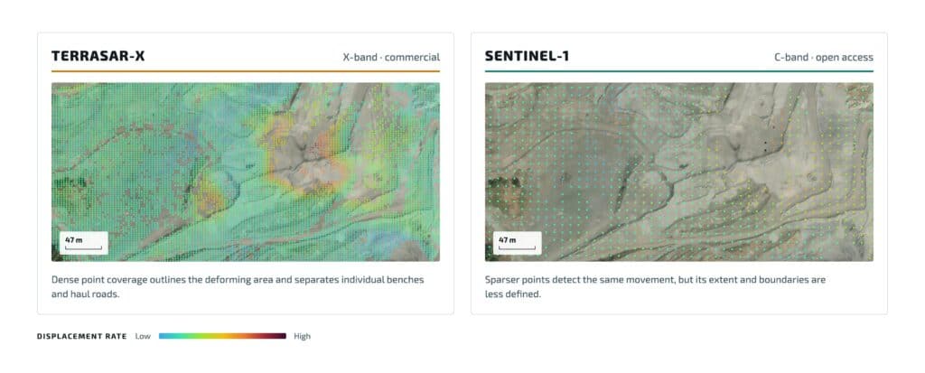
Figure 1: TerraSAR-X (X-band) and Sentinel-1 (C-band) InSAR results over the same quarry site. TerraSAR-X yields 15 times more measurement points, showing the resolution difference between commercial and open-access data. Read the full story here.
Higher resolution isn't always "better". It comes with smaller swath widths, higher costs and often additional concessions covered below. The right resolution is the one that matches your feature of interest, project aims, and budget.
Which Radar Band Is Best for InSAR: X-, C-, or L-Band?
Radar band refers to the wavelength of the signal a SAR satellite transmits and receives. It is arguably the single biggest driver of which sensor will work for a given area of interest (AOI), since wavelength governs how the signal interacts with vegetation and how sensitive it is to small movements. Three bands are generally considered for commercial InSAR projects:
- X-band (~3 cm): The shortest wavelength, the greatest sensitivity to small surface changes, and the band used by most of the highest-resolution commercial sensors. However, it barely penetrates vegetation, meaning coherence degrades quickly over vegetated or agricultural areas. Examples: TerraSAR-X, COSMO-SkyMed, ICEYE, Capella.
- C-band (~5.6 cm): The workhorse band, balancing resolution against moderate penetration, with generally consistent coherence in mixed land cover. Examples: Sentinel-1, RADARSAT-2, RADARSAT Constellation Mission [RCM].
- L-band (~23 cm): The longest wavelength and best canopy penetration, maintaining more coherence over vegetated terrain. The trade-off is lower sensitivity to very small movements. Examples: ALOS-2, SAOCOM, NISAR.
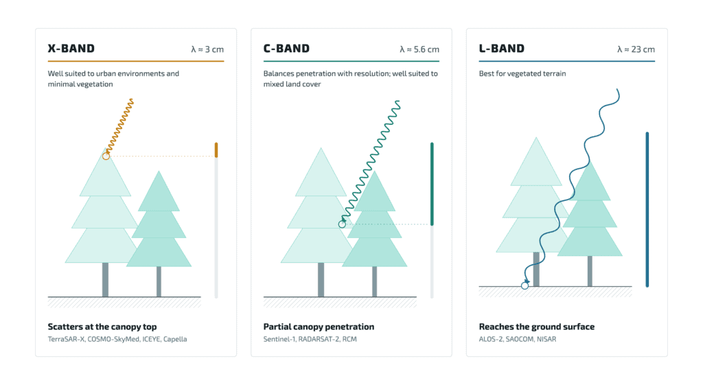
Figure 2: Schematic diagram showing X-, C-, and L-band radar penetration depth through a vegetated canopy.
For a vegetated slope, L-band may be the only viable option. For an urban structure, X-band's resolution and coherence over hard surfaces often make it the clear choice.
What is coherence?
Coherence measures how similar the radar signal from the same patch of ground is between two acquisitions, on a scale from 0 to 1. High coherence means the surface has stayed consistent enough for movement to be measured reliably. Low coherence, caused by vegetation scattering, snow, flooding or ploughing, makes the signal noisy or unusable. Hard, stable surfaces such as buildings, exposed rock and infrastructure often stay coherent for years.
Free vs. Commercial SAR Data: Price, Archive Depth, and Coverage
Sentinel-1, the C-band mission operated by the European Space Agency [ESA] for the EU Copernicus programme, is free and collects data globally on a fixed schedule, with a public archive stretching back to 2014. As a result, it is often the starting point for InSAR feasibility assessments and is unmatched for establishing long-term deformation patterns. NISAR, the joint NASA-ISRO L-band mission launched in 2025, adds another free and open option.
Commercial sensors (e.g. TerraSAR-X, COSMO-SkyMed, Capella, ICEYE, RADARSAT-2) are priced per scene through tasking or subscription agreements and do not generally acquire imagery over areas where they have not been tasked. As a result, the spatial coverage and archive depth for these missions are highly variable, some sites have rich commercial archives while others have none before a project begins.
For projects that require a multi-year deformation history, open-access Sentinel-1 data may be the only option regardless of resolution preference. For projects that need ongoing monitoring at sub-metre resolution over a new AOI, tasking collection through a commercial constellation is likely the best choice. At CATALYST, we often run a "tip and cue" approach: open data flags the general zone of historical movement, then commercial data confirms and monitors it at a higher resolution.
What is tip and cue?
Tip and cue is a two-stage monitoring approach. Openly available, wide-area Sentinel-1 data "tips" analysts to where historical movement has occurred. Higher-resolution commercial satellites are then "cued" to collect, process, confirm and monitor those specific areas in detail. Commercial tasking is only paid for where it adds value.
SAR Satellites for InSAR at a Glance
The table below summarizes the satellites discussed in this guide, with the band each uses and how its data is accessed.
| Satellite | Band | Operator | Data access | First launch |
|---|---|---|---|---|
| Sentinel-1 | C | ESA / EU Copernicus | Free and open | 2014 |
| RADARSAT-2 | C | MDA | Commercial | 2007 |
| RCM | C | CSA | Free with conditions | 2019 |
| TerraSAR-X | X | Airbus | Commercial | 2007 |
| COSMO-SkyMed | X | ASI | Commercial | 2007 |
| ICEYE | X | ICEYE | Commercial | 2018 |
| Capella | X | Capella Space | Commercial | 2020 |
| ALOS-2 | L | JAXA | Commercial | 2014 |
| SAOCOM | L | CONAE | Commercial | 2018 |
| NISAR | L (and S) | NASA/ISRO | Free and open | 2025 |
What Other Factors Affect InSAR Sensor Choice?
Line of sight [LOS]: SAR data is acquired at an angle, not directly overhead, by satellites travelling either north-to-south (descending) or south-to-north (ascending). This means that deformation is measured along a single inclined LOS, and the orientation of some sites is better suited to ascending or descending viewing geometries. CATALYST is also able to combine the ascending and descending LOS to determine the pure vertical and east-west components of movement (see Figure 3).
Generally, satellites look east or west making InSAR largely insensitive to north-south motion. However, recent advances in mid-inclination satellites, such as Capella, do allow for measurement of north-south movement.
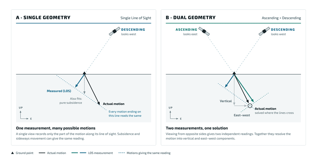
Figure 3: A single line of sight (A) cannot distinguish between different ground motions that produce the same reading. Combining ascending and descending passes (B) separates the motion into vertical and east–west components.
Incidence angle: The incidence angle is the angle of the radar line of sight from vertical. Smaller incidence angles provide greater sensitivity to vertical displacement, while larger incidence angles increase sensitivity to horizontal displacement . In steep terrain, viewing geometry can introduce layover, foreshortening, and radar shadow, reducing measurement reliability or preventing effective monitoring in affected areas.
Coherence: Coherence measures how consistent the radar signal is between acquisitions. Temporal decorrelation, the loss of coherence over time, is often caused by vegetation growth, snow, or normal movement of features (e.g. traffic, equipment presence), which can limit whether a reliable time series is possible at all. In these cases, band choice is important, and it may also be necessary to deploy permanent corner reflectors to provide a strong, stable return signal.
Revisit cadence: The satellite's repeat cycle dictates how often images are acquired over the same area. More frequent revisits mean less movement is captured between consecutive images, which helps track fast-moving ground, preserves coherence and allows new movement to be detected sooner. Sentinel-1 follows a fixed cycle of typically 6 or 12 days, while commercial constellations can be tasked more frequently, at additional cost per acquisition. The right cadence depends on how fast the site moves and how quickly changes need to be reported.
Displacement rate and extent: How fast the ground is moving, and over what area, both affect which sensor can measure it. InSAR measures movement as a change in phase. If the ground moves too far between two acquisitions, roughly more than a quarter of the wavelength, the signal becomes ambiguous unless it is spread across a wide enough area. Sites with isolated fast-moving areas, such as active landslides or mine walls, may need frequent revisits, a longer wavelength such as L-band, or both. Very slow movement over wide areas, such as gradual subsidence, can instead benefit from the greater sensitivity of X-band and a longer time series to separate real deformation from noise.
Baselines and orbital tube: InSAR compares images over the same area taken at regular intervals, however, the precise position of the satellite in orbit when the images are taken is different. The distance between those positions is the perpendicular baseline. Large perpendicular baselines reduce coherence and make results more sensitive to errors in the elevation model used during processing. To keep baselines small, satellites are held within a narrow corridor known as an orbital tube. Sensors with tight orbital control, such as Sentinel-1, produce consistently small baselines and reliable time series. Orbital control varies across commercial constellations.
How to Choose the Right SAR Satellite for Your Project
The “right” satellite for your project is rarely obvious from a spec sheet. It depends on the interplay between all the factors above, your site's specific conditions, and the objectives of the monitoring programme.
This is where CATALYST’s InSAR experts come in. CATALYST’s InSAR pipeline is sensor-agnostic, allowing us to work with clients to understand their area of interest’s land cover, terrain, expected movement, timeline, and budget, then recommend the sensor (or combination of sensors) that fits best.
Our goal is a monitoring programme matched to your area’s specific challenges, not a one-size-fits-all sensor choice. If you're not sure where your project sits in the trade-offs above, our team is ready to discuss the best approach with you.
Contact CATALYST
Frequently Asked Questions
There is no single best satellite for InSAR. The right choice depends on land cover, terrain, expected rate of movement, required history, and budget. Sentinel-1 is a strong starting point for regional and long-term analysis, sub-metre X-band sensors suit individual structures, and L-band sensors perform best over vegetation.
For many regional projects, yes. Sentinel-1 is free, has a global archive back to 2014, and covers wide areas, which makes it ideal for feasibility studies and long-term baselines. Its medium resolution limits detail on small structures, where commercial high-resolution data is often the better fit.
The difference is wavelength. X-band (about 3 cm) is the most sensitive to small movements but loses coherence over vegetation. C-band (about 5.6 cm) balances sensitivity and penetration. L-band (about 23 cm) penetrates vegetation best and maintains coherence over vegetated terrain, at the cost of lower sensitivity to very small movements.
Yes. Each interferogram is formed from images taken by the same sensor in the same viewing geometry, but results from different sensors can be combined in one monitoring programme. CATALYST often uses free Sentinel-1 data to find historical movement, then commercial data to confirm and monitor it at higher resolution.
InSAR measures movement along the satellite's line of sight. Combining ascending and descending passes lets analysts separate vertical from east-west motion, and reduces the risk that a site's slope orientation hides movement from one viewing geometry.
About the author
Dr. Ben Conway Jones is an InSAR Specialist at CATALYST. Ben has a background in Geology, a PhD in Geophysics from the University of Cambridge and has been providing commercial InSAR solutions for nearly 5 years. These projects have spanned many sectors, including mining, infrastructure and oil & gas.