
Satellite Interferometric Synthetic Aperture Radar (InSAR) provides spatially continuous ground deformation measurements across wide areas. As a fully remote technology capable of detecting millimetre-scale displacement, InSAR is increasingly being integrated into engineering projects as both a monitoring tool and a means of baseline assessment.
Niscemi is a town in southern Sicily, Italy, situated atop a ~200 m topographic plateau. The local geology is sandstone overlying clay, making the area particularly susceptible to landslides during periods of heavy rainfall. Water percolates into the sandstone but cannot drain through the underlying clay, causing it to pond within the rock mass, reducing strength and acting as a catalyst for slope failure. On the 25th of January 2026, a slope on the southern boundary of Niscemi catastrophically failed. The landslide forced the evacuation of over 1,000 residents, prompted the closure of major roads, and left numerous buildings declared unsafe. The Italian government provided €100 million in emergency funding, with total damages expected to exceed €1 billion.
This case study uses the 2026 Niscemi landslide to explore three key themes:
- How InSAR quantifies displacement from the scale of individual buildings over days to regional deformation patterns over years
- How deformation data can be correlated with environmental data to identify the triggers and mechanisms driving slope movement
- How wide-area and site-specific analysis supports more informed site characterisation and stronger risk assessments.

Data & Processing
CATALYST has over 40 years of experience as an industry leader in remote sensing and has developed a wide range of technologies and algorithms for processing satellite imagery, including InSAR data. For this study, a stack of archive Sentinel-1 images spanning Niscemi and the surrounding area was obtained in both ascending and descending lines-of-sight (LOS), reaching back six years prior to the event. By combining both LOS directions, it is possible to derive pure vertical and horizontal longitudinal displacements across the study area.
Short-Scale Results: Metres & Days
Displacement was first assessed over the six-day period immediately preceding the landslide. Within a small, localised area of approximately 50 metres, where the headscarp eventually formed, over 10 mm of displacement was detected (Figure 1). This is a substantial signal over such a short timeframe and represents a clear, immediate precursor to failure. Viewed in context, this displacement marks a sharp departure from the preceding six-month trend and is consistent with the onset of the heavy rainfall that triggered the event.
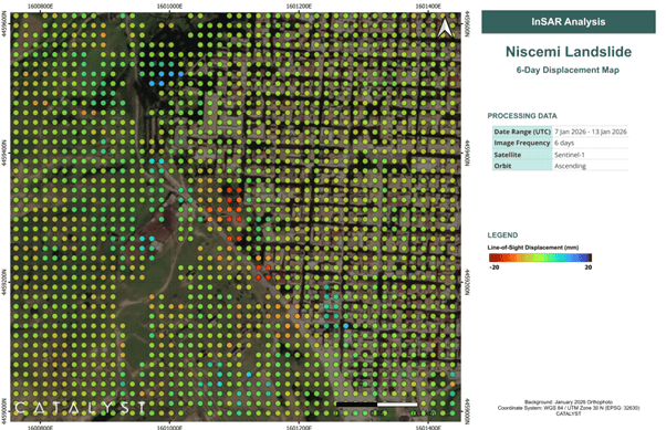
Figure 1 – Line-of-sight displacement in the last 6-day period prior to failure.
Medium-Scale Results: Hundreds of Metres & Months
While short-term InSAR analysis enables rapid responses to quickly evolving instabilities, CATALYST also examined the months preceding the event to assess whether earlier warning signals were present. The period from July 2024 to July 2025 was considered, to evaluate how the slope responded to the previous wet season and what lessons could have been carried forward into 2026.
Across the slope, isolated areas of both uplift and subsidence were identified (Figure 2). Critically, the displacement time series of upslope subsidence signals and downslope uplift signals were consistent but of opposite polarity - a clear indicator of small rotational slumps, where the headscarp area subsides while the slump toe rotates upward. These localised slumps were distributed across the slope that failed in 2026, and their movement was coincident with precipitation events. This demonstrates that the region could have been identified as an area of significant concern many months before the 2026 failure.
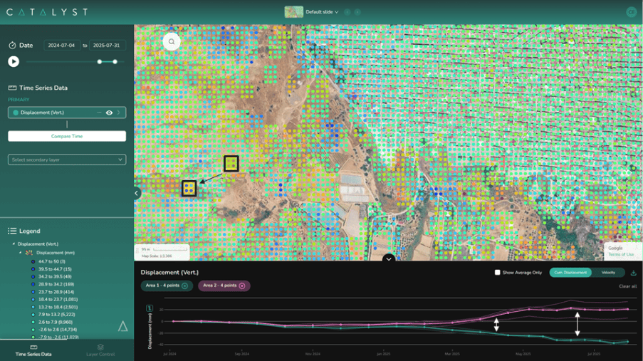
Figure 2 – InSAR displacement data visualised in the CATALYST INSIGHTS platform, showing paired upslope subsidence and downslope uplift signals characteristic of rotational slumping.
Large-Scale Results: Kilometres & Years
Exploiting the full six-year deformation record, CATALYST assessed the broader environmental factors contributing to the 2026 failure. Displacement across the block south of Niscemi was spatially variable, with the greatest movement observed on its eastern extent, where cumulative vertical displacement reached 15 cm over six years. Longitudinal displacement of up to 25 cm was also recorded along a river valley corridor carrying major road infrastructure.
Displacement was not temporally continuous but occurred in distinct steps corresponding to periods of elevated precipitation, a pattern that persisted consistently across the full six-year record. Presented within the CATALYST INSIGHTS visualisation platform alongside monthly precipitation data, this correlation is unambiguous: significant rainfall events have repeatedly driven slope movement at Niscemi (Figure 3). The storms forecast for January 2026 were, therefore, very likely to trigger further displacement.
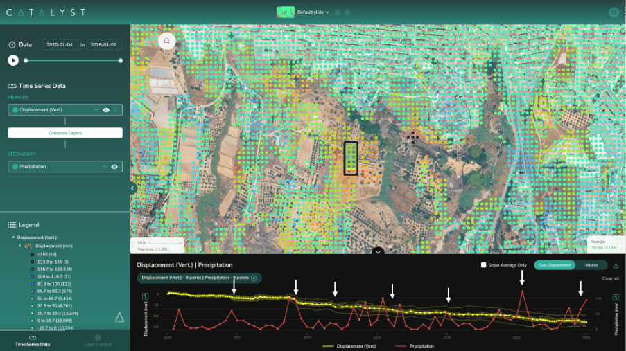
Figure 3 – Cumulative InSAR displacement time-series (yellow) and monthly precipitation (red) over six years, highlighting the strong correlation between rainfall events and slope movement.
Conclusions
The 2026 Niscemi landslide was the culmination of years of incremental slope movement, driven by recurring large precipitation events and expressed in areas as small-scale slumping across the affected block. InSAR is uniquely positioned to provide retrospective, quantitative insight into historical slope instability. Furthermore, InSAR is equally well-suited to ongoing wide-area monitoring by detecting abnormal or accelerating deformation early enough to inform ground-based intervention before conditions become critical.
Watch the full webinar recording to learn more about the project, outcomes, and implementation details.