
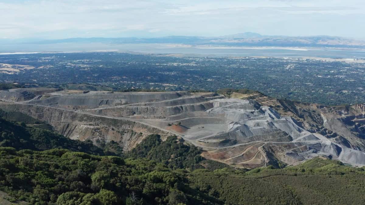
Continuous wide-area displacement monitoring in an active mining environment, comparing Sentinel-1 and TerraSAR-X
Author: Dr. Ben Conway-Jones, InSAR Specialist, CATALYST
Following several high-profile failures at mine sites, including the Brumadinho tailings dam collapse in 2019, operators have faced growing pressure from regulators, investors and the public to comprehensively monitor slopes and storage structures across the whole site. This is a challenge for engineers, whose measurements have traditionally been limited to where instruments are installed. Satellite InSAR provides a consistent, time-stamped displacement record across the entire site to support reporting and review. InSAR can also reduce the need for frequent field surveys by showing where ground instruments will add the most value. Permanente Quarry is an excellent place to test how satellite InSAR meets that challenge. It is a large, active site with a documented history of instability, including a rockslide in 2019 and long-standing concerns at the West Materials Storage Area. This study set out to answer two questions: can InSAR confirm and characterise movement where a problem is already suspected, and can it find movement where no one was looking?
Key Takeaways
- Satellite InSAR measured ground displacement across the whole of Permanente Quarry from September 2019 to September 2020, irrespective of instrumented locations.
- TerraSAR-X detected up to 90 mm of line-of-sight displacement at the West Materials Storage Area (WMSA), in addition to multiple other hotspots in excess of 30 mm.
- Free Sentinel-1 data confirmed that the WMSA slope was active; higher-resolution TerraSAR-X data identified specific surface features that were moving.
- Due to the fact radar satellites have multiple years of archived imagery (Sentinel-1 since 2014), displacement history can be reconstructed for newly identified instabilities.
Why is it hard to monitor ground movement across a large mine site?
Permanente Quarry, in the hills above Cupertino, California, was once the largest operating surface mine in Santa Clara County, with decades of continuous production. Like any large surface mine, the footprint is constantly changing and measuring slope instability is critical. That scale creates a real monitoring problem. A mine site is a mosaic of pit faces, waste storage areas, haul roads, and legacy workings, often spread across hundreds of acres, all changing at different rates for different reasons and presenting different risks. Ground instruments such as survey prisms, extensometers, and inclinometers are precise but they only measure displacement where they are installed. Extending that same density of coverage across an entire site is rarely practical, so operators must choose where to concentrate their monitoring network.
How does satellite InSAR monitor an entire mine site?
Satellite InSAR (Interferometric Synthetic Aperture Radar) takes a different approach. Every satellite image acquisition covers the whole site at once, producing a displacement measurement at every coherent point on the property (a location whose radar signal stays consistent between acquisitions, such as bare rock, benches, and structures), not just at instrumented locations. This gives operators a site-wide baseline that can detect new movement wherever it occurs, complementing any targeted monitoring already in place. Areas that are excavated between satellite passes may lose coherence and drop out of the measurement, so coverage is densest on surfaces left undisturbed between acquisitions. Notwithstanding, CATALYST has a suite of tools and techniques to maximise coverage in collaboration with mining clients.
Why Permanente Quarry makes a strong test case
Permanente Quarry provides an excellent opportunity to demonstrate the capabilities of InSAR. At the West Materials Storage Area (WMSA), an overburden stockpile located above Permanente Creek, evidenced ground movement has been an established geotechnical concern for several years. Meanwhile, the rest of the site remains an active, changing environment. This combination lets us examine at how InSAR performs both at a known problem area and across the wider site.
Data and method: TerraSAR-X and Sentinel-1
CATALYST used its proprietary InSAR workflow to process data in the months following a notable rockslide in 2019 to examine subsequent slope stability. Two independent satellite missions imaged the site regularly from September 2019 to September 2020: TerraSAR-X [TSX]and Sentinel-1 [S1]. The InSAR results shown here are based on 33 TerraSAR-X images on its 11-day repeat cycle and 28 Sentinel-1 images acquired every 12 days. The two missions differ in important ways. TerraSAR-X offers higher resolution (about 3 m, compared with roughly 20 m for Sentinel-1) and uses X-band radar (about 3.1 cm wavelength) rather than C-band (about 5.5 cm), which makes it more sensitive to small displacements but more susceptible to dropped coverage in vegetated environments. Sentinel-1, part of the European Union’s Copernicus programme, is free and open, with a near-global archive dating back to 2014 that is a cost-effective option, especially for retroactive studies.
Table 1: Sentinel-1 and TerraSAR-X compared for mine monitoring
| Sentinel-1 | TerraSAR-X | |
|---|---|---|
| Operator | European Union Copernicus programme / ESA | DLR and Airbus |
| Radar band (wavelength) | C-band (about 5.5 cm) | X-band (about 3.1 cm) |
| Resolution in this study | About 20 m (Interferometric Wide swath) | About 3 m (StripMap) |
| Revisit in this study | 12 days (up to 6 days presently) | 11 days |
| Data access | Free and open | Commercial, tasked on request |
| Archive | Near-global, systematic since 2014 | Since 2007, where previously tasked |
| Best used for | Wide-area screening and historical baselines | Local-scale detail and pinpointing the source of movement |
What did InSAR detect across the full site?
Across the full site, the finer resolution of TerraSAR-X picks out several discrete displacement signatures. Over one year, the largest signal on the site was approximately 90 mm of line-of-sight [LOS] displacement away from the satellite, on the eastern limit of the WMSA, with a further 60 mm displacement zone at its crest. On North Ridge, at the edge of the quarry property, TSX also identified two separate hotspots of around 35mm each. The North Ridge hotspots were not areas that CATALYST had specifically targeted. They were detected simply because they fell within the same site-wide dataset.
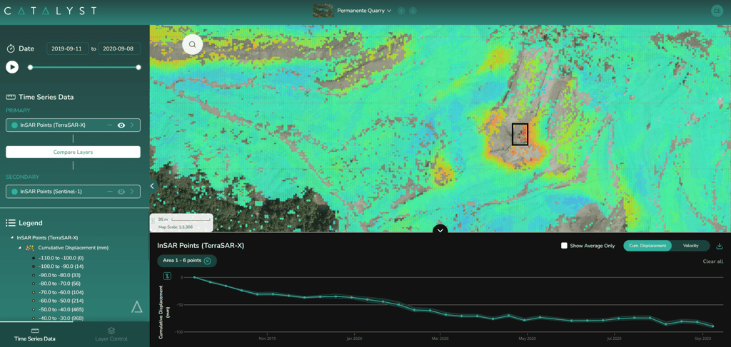
Sentinel-1 vs TerraSAR-X at the West Materials Storage Area
Focusing on the WMSA, a storage area with known instability concerns, Sentinel-1 shows two broad zones of displacement roughly 200 metres wide, with movement towards the satellite within a southern zone of the WMSA and movement away from the satellite further to the east. The data shown here comes from a single line of sight, which provides a one-dimensional displacement measurement. [It is possible to resolve movement in the vertical and east-west directions by adding a second viewing geometry (combining ascending and descending passes)], A single Sentinel-1 track is enough to establish that the slope is active, where it is moving, and the overall velocity.
By comparison, TerraSAR-X picks out considerably more detail in the displacement pattern over the same area, showing several discrete zones tied to individual benches rather than one broad area. One of these localized displacement zones shows approximately 70 mm of displacement over the year, concentrated mainly between December and April.
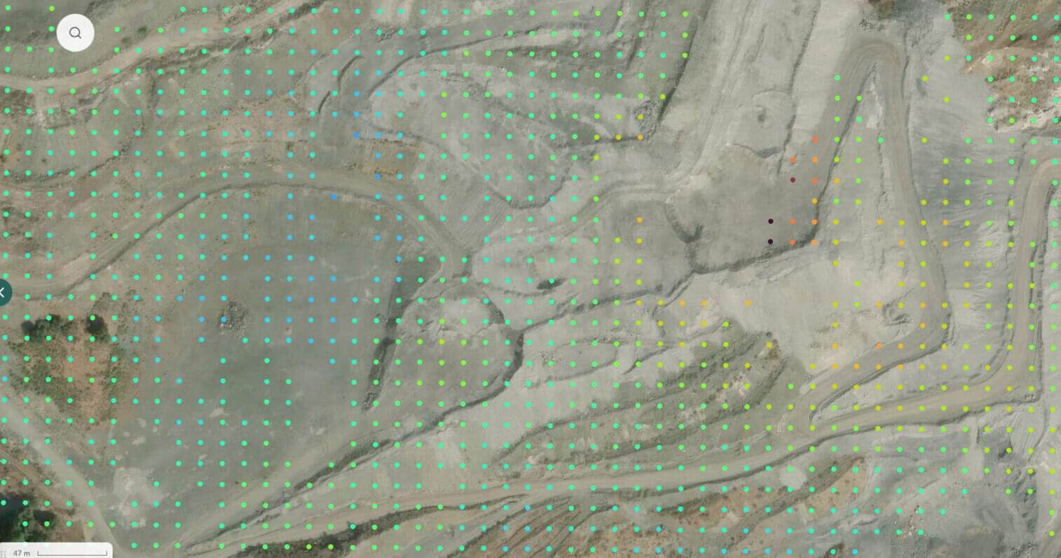
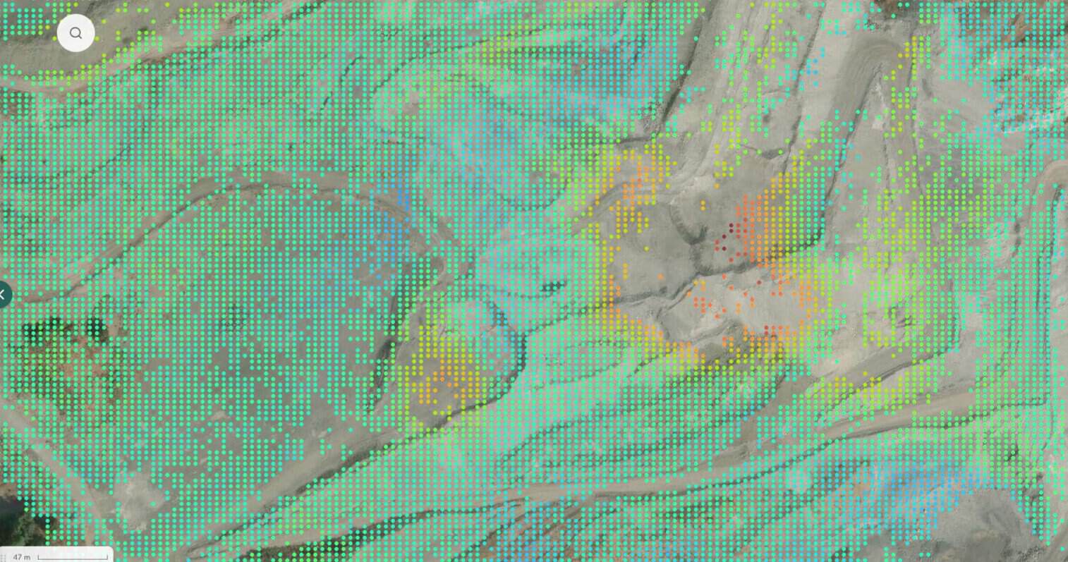
Figure 2 – InSAR displacement over the West Materials Storage Area (WMSA) from TerraSAR-X and Sentinel-1.
Which satellite is right for mine monitoring?
The combination of TerraSAR-X and Sentinel-1 shows how the two sensors complement each other well. Sentinel-1's's wide swath and frequent, freely available acquisitions make it well suited to broad, low-cost surveillance and to long historical studies, since it has provided near-global, consistent coverage for more than a decade. TerraSAR-X’s finer resolution is better suited to pinpointing which bench or feature is driving a signal once one has been identified, which is what a site team needs before acting on the ground. In practice, a cost-effective approach is to screen the whole site with Sentinel-1, then use a high-resolution sensor such as TerraSAR-X to determine the precise location and temporal evolution of any detected areas of concern.
Can InSAR measure ground movement from before monitoring began?
InSAR also offers value before a monitoring program even begins as SAR satellites have been systematically acquiring data for years (Sentinel-1 since 2014, and commercial missions wherever they were previously tasked), displacement history can be reconstructed retrospectively. That matters most for a newly identified instability, where a historical archive can show how long the ground has been moving and whether current behaviour is new, accelerating, or long-term creep. This is context that ground instruments installed after the fact cannot provide on their own.
What InSAR adds to mine monitoring
Together, these results show what satellite InSAR adds to a large, active mine site: site-wide coverage that catches movement outside instrumented areas, the detail to pinpoint which features are moving, and a historical record that gives newly identified problem areas a documented past as well as a monitored future. Since each acquisition produces a consistent, dated record, the same data can also support routine reporting and independent review. Furthermore, by showing where movement is actually occurring, InSAR helps operators focus field surveys and ground instruments where they are most needed. For an industry where missing a developing hazard is costly and instrumenting everywhere is not feasible, InSAR is a practical addition to existing monitoring programs.
Contact CATALYST
Contact CATALYST
Do you want to know what is moving across your site, and for how long? Talk to the CATALYST InSAR team about site-wide monitoring and a look back through the satellite archive.
Frequently asked questions
InSAR (Interferometric Synthetic Aperture Radar) mine monitoring uses repeated radar satellite images to measure ground displacement across an entire mine site, including pit walls, benches, waste dumps, stockpiles, and haul roads, without installing instruments on the ground.
Under good conditions, time-series InSAR can detect displacement at the millimetre scale along the satellite’s line of sight. Accuracy depends on the radar band, the number of images, surface coherence, and atmospheric conditions. At Permanente Quarry, TerraSAR-X resolved displacement zones tied to individual benches.
Sentinel-1 is a free C-band mission with a near-global archive since 2014, suited to wide-area screening and historical analysis. TerraSAR-X is a commercial X-band mission with higher resolution and greater sensitivity to small displacements, suited to pinpointing specific benches or deformation features.
No. InSAR complements instruments such as survey prisms, extensometers, and inclinometers. It provides site-wide coverage and historical context, while ground instruments provide continuous, high-frequency measurements at critical locations.
Yes, where archive imagery exists. Sentinel-1 has acquired data systematically over most land areas since 2014, so displacement history can often be reconstructed for years before a problem was noticed.
Surfaces that are excavated or re-graded between satellite passes lose coherence and cannot be measured reliably. Undisturbed surfaces, such as completed benches, stockpile slopes, and surrounding ground, typically measure well. By working closely with users and understanding the timing and extent of active works, it is possible for CATALYST to generate results designed to minimize this coverage loss.
InSAR provides a site-wide displacement record that can support geotechnical reporting and independent review, including for tailings facilities under standards such as GISTM. It complements, rather than replaces, the ground instrumentation that regulations typically require at critical locations.
About the author
Dr. Ben Conway Jones is an InSAR Specialist at CATALYST. Ben has a background in Geology, a PhD in Geophysics from the University of Cambridge and has been providing commercial InSAR solutions for nearly 5 years. These projects have spanned many sectors, including mining, infrastructure and oil & gas.