

An exploratory pilot project in conjunction with Network Rail's Wessex Route
Britain's rail network faces a growing challenge. Climate variability, ageing earthworks and dense vegetation corridors are driving up the frequency and cost of weather-related disruption: from embankment failures and track washouts to vegetation fall-in. According to Network Rail’s fourth climate adaptation report, the financial consequences are substantial: weather-related compensation costs exceeded £370 million between 2021 and 2024, with 2023 and 2024 being the most expensive on record.
For many global Rail Operators, traditional inspection regimes can reflect the practical realities of managing a complex, sprawling network. Vegetation surveys, conducted on a three-year cycle, provide a valuable encroachment baseline but the environment changes continuously, particularly in transient storm conditions, and the picture they capture begins to age the moment they are conducted. Similarly, ground displacement monitoring prioritizes sites with a known history of concern, but locations that have never failed, yet may be quietly evolving, often go unnoticed.
Network Rail’s Wessex Route is one of the most operationally demanding on the network, with clay-rich geology, heavy tree cover and significant exposure to summer extremes. An area determined appropriate to explore whether satellite Earth Observation (EO) data could complement existing programmes with a continuous, location-specific and route-wide solution to augment surveys and extend visibility to areas that traditional methods alone cannot economically cover.
The Pilot
Over twelve weeks, CATALYST and Network Rail collaborated to develop a working prototype for a decision-support solution that generates daily, route-level risk indicators for flooding, vegetation fall-in and ground-movement analysis across a portion of the Wessex Route.
Three sections of rail were selected based on alignment with the Wessex Route’s historical information covering vegetation encroachment, flooding and remote condition monitoring. These stretches of rail were further broken down into 110-yard segments to ensure consistency and integration with existing workflows.
The prototype integrated multiple satellite and geospatial data sources:
- SAR imagery for InSAR ground deformation
- Optical imagery for tree proximity, height and health analysis
- National flood susceptibility data for flood risk assessments
- Short-range meteorological forecasts for daily risk updates
During the pilot, forward-looking risk indicators for deformation, flooding and vegetation fall-in were updated daily for the subsequent three days. These indicators were normalized to a consistent traffic-light scoring system so that up-to-date information could be made available to potentially inform and complement operational planning and response.
CATALYST's proprietary SAR and optical processing workflows underpinned the solution. Prototype outputs were provided through an interactive web map with geospatial export that permitted segment-level inspection and weather-forced forecast overlays.
Exploring Transformative Risk Intelligence
The pilot explored how to provide additional coverage, frequency and improve forward visibility of weather events Together, these advancements have the potential to shift rail infrastructure monitoring from a periodic, reactive activity towards a more continuous and anticipatory one.
For example, vegetation risk can be monitored regularly using LiDAR imagery or stereo-optical mapping, combined with satellite-derived stress indicators. Regular views of canopy health and proximity risk across the full corridor could replace the need for the snapshot provided in a three-year survey cycle. Teams responsible for vegetation clearance would then be able to prioritize their clearing programmes using objective, up-to-date data. Additionally, daily weather forecasts add a further layer, flagging sections where fall-in risk could be heightened in the short-term requiring immediate attention when conditions change.
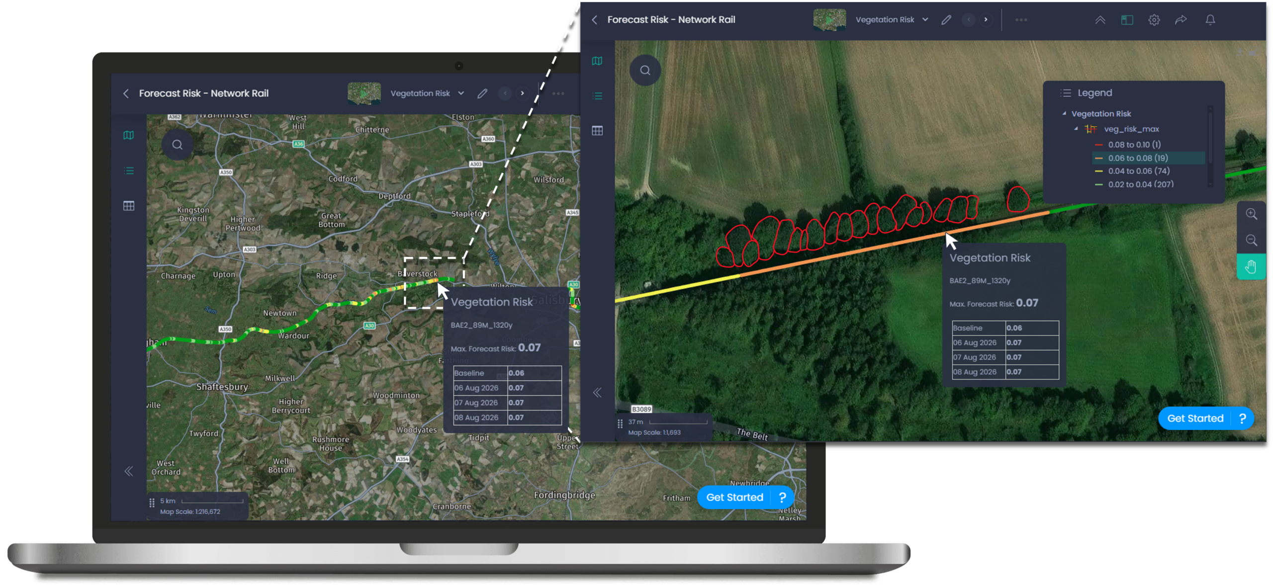
Figure 1 - Screenshot from the CATALYST INSIGHTS solution, showing the prototype output that illustrates an area of moderate to high vegetation fall-in risk. Outputs are presented as readings along segments of track. These outputs are for illustrative purposes only.
The pilot also explored combining flood susceptibility mapping and short-range meteorological data to give drainage engineers potentially three days of advance warning before conditions at specific locations were likely to become critical. The 72 hour lead time could transform a reactive response to a proactive, targeted approach, with the potential to reduce delay minutes, lower incident response costs and better outcomes for passengers and rail operators.
The inclusion of InSAR analysis in the pilot was leveraged to measure ground deformation along the rail corridor. The data collected from the satellite imagery can be disaggregated into three types of information used to identify and quantify the risk to operations:
- Seasonal signals - relate to shrink-swell behaviour in the clay-rich soils typical of the Wessex Route
- Long term cumulative displacement – can indicate a slow-developing instability before it becomes visible on the ground
- Accelerating deformation – flags areas moving significantly faster than their historical baseline and may be approaching a critical threshold.
During the pilot ground-movement analysis was explored as a prospective capability only and is shown here for illustrative purposes. It was not reviewed, validated or endorsed by Network Rail for operational use, inspection targeting or risk management. This ground-movement analysis was developed as a prototype capability during the pilot, demonstrating how InSAR-derived deformation data could support inspection targeting and asset risk prioritization.
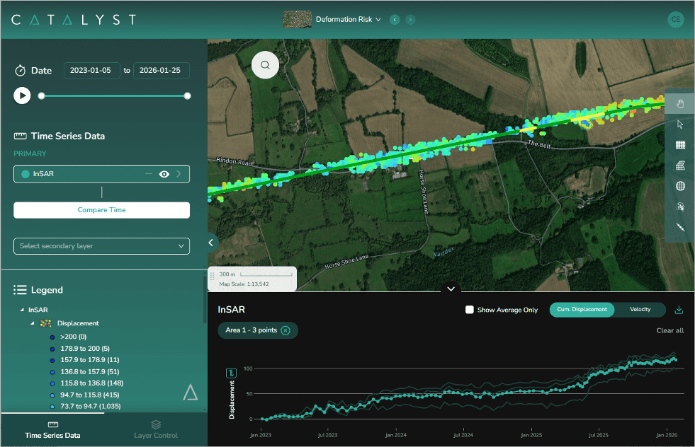
Figure 2 – Screenshot from the CATALYST INSIGHTS solution highlighting an area where increased displacement over 6 months has been flagged as moderately accelerating for illustrative purposes.
Across the hazard types explored, the prototype pointed to how satellite-derived insights could, subject to further development and validation, support data-driven scheduling of inspection and maintenance activity, more confident operational decision-making during severe weather, and a stronger evidence base for longer-term infrastructure investment. For Route Managers, this would permit proactive approach to anticipated weather events and less time reacting after the fact.
Looking Ahead
The pilot is the foundation for a broader commercial solution that CATALYST plans to make available to global Rail Operators on a network-scale basis. Future development will extend integration with existing Operational workflows and add further hazard classes, such as wildfire and leaf-fall in risk, alongside a growing library of configurable layers that can be tailored to specific route environments and operator priorities.
CATALYST is actively seeking partnerships with rail operators, infrastructure managers and geotechnical specialists who want to explore what satellite-enabled risk monitoring could look like on their network. If that's you, we'd welcome the conversation.