Catalyst.earth Logo
Catalyst.earth Logo
CATALYST INSIGHTS • URBANSAR

Monitoring the unseen risk beneath growing cities

Millimetre-scale movement monitoring across densely populated cities, large-scale construction, and complex underground infrastructure.

INSAR Technology
Millimetre Accuracy
City-Scale Coverage
Multi-Sensor Compatible
Request A Briefing
UrbanSAR: City-Scale Building Movement Monitoring
30mm
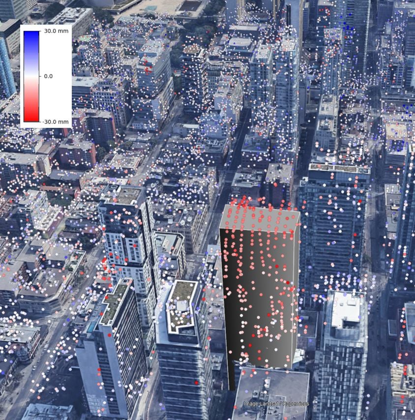
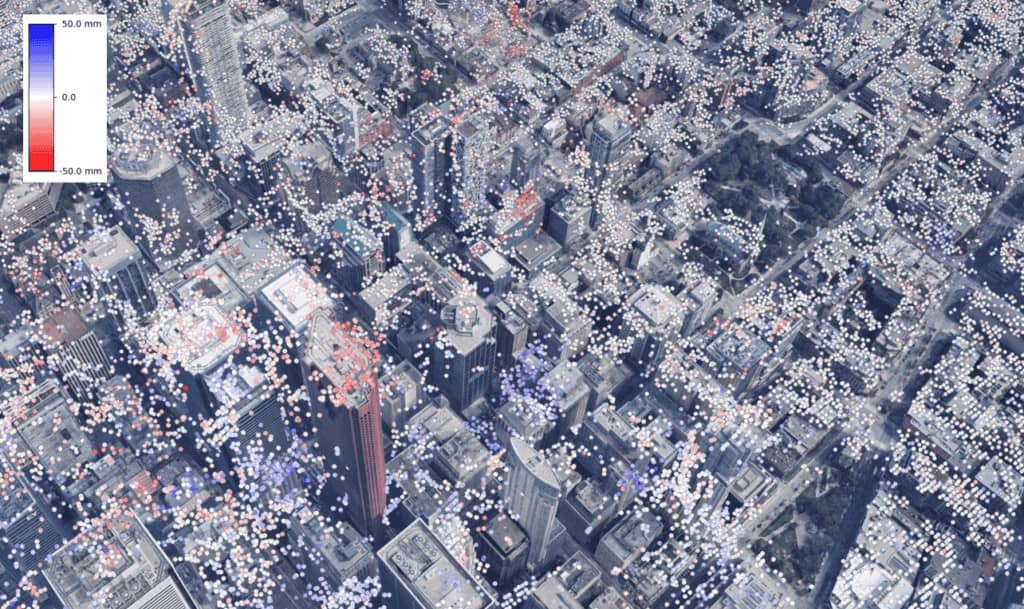
Movement UrbanSAR detected on the upper floors of new towers above Toronto's Yonge and Eglinton subway corridor, vertical differentiation monitoring rarely reaches.
Read the article
The Solution

A satellite data processing pipeline purpose-built for the city

Standard InSAR uses radar imagery to detect surface movement, but in dense urban environments tall buildings cause significant measurement errors. UrbanSAR resolves this through a purpose-built processing pipeline that correctly assigns every measurement to its true physical source.

Using proprietary building corrections and point-location accuracy, UrbanSAR delivers reliable, millimetre-level deformation monitoring across entire cities, passively and on a repeat satellite cycle. Complex infrastructure can now be monitored cost-effectively by the construction firms, insurers, asset managers, and government agencies responsible for identifying and remediating risk before it becomes expensive failure.
UrbanSAR delivers
  • Proprietary correction of ground measurements, enabling more accurate deformation detection than the industry standard.
  • Accurate point-location assignment, correctly attributing movement to buildings or ground surfaces and removing ambiguity caused by tall structures.
  • Greater coverage, with significantly more measurements in dense urban areas.
  • City-scale monitoring from space, reducing the need for field crews, site access, or physical installation.
  • Sensor-agnostic approach to meet specific project and budget requirements.
UrbanSAR floor-by-floor vertical displacement on a Toronto tower, with surrounding buildings colour-coded by movement
The Problem

Cities are building upward faster than we can monitor them

  • 30mm
    Movement UrbanSAR detected on the upper floors of new towers above Toronto's Yonge and Eglinton subway corridor, vertical differentiation monitoring rarely reaches.
  • $Millions
    The cost to deploy and maintain city-wide ground sensor networks, which still leave large areas unmonitored.
  • Gaps
    Standard satellite InSAR mis-assigns signals from tall buildings, creating displacement errors and large data gaps in dense cities.
Dozens of high-rise towers now sit directly above new subway extensions and alongside buildings decades old. Residents report sinkholes, cracked pavements, and road closures, yet there has been no practical way to see what is moving, where, and why across an entire urban corridor.
Conventional monitoring is precise but limited to the single structure it is attached to. The tunnel underneath, the neighbouring tower, the road between them all fall outside its reach. And city-wide ground sensor networks would cost millions to deploy and maintain while still leaving gaps.
Why conventional approaches fall short

Every current method leaves a gap in dense urban settings

  • Ground sensors are localized
    Movement UrbanSAR detected on the upper floors of new towers above Toronto's Yonge and Eglinton subway corridor, vertical differentiation monitoring rarely reaches.
  • Sensor networks are prohibitively expensive
    Deploying and maintaining city-wide networks would cost millions throughout a project lifecycle.
  • Standard satellite InSAR distorts in cities
    Tall buildings block line of sight to the ground; radar reflections are incorrectly attributed, causing errors and data gaps.
  • Monitoring is planned too late
    There is no baseline of conditions before works begin, critical for compliance and claims.

The Complete Monitoring Pipeline

From raw satellite data to decision-ready output

UrbanSAR executes a complete deformation monitoring workflow across five stages.
Step 01
Data Selection
CATALYST works with clients to understand their requirements and site-specific challenges and recommend an appropriate data source and resolution. UrbanSAR is sensor-agnostic, ensuring consistent quality regardless of the satellite data used.
Step 02
Building Correction
Removes signal distortions introduced by tall buildings, enabling deformation detection at greater accuracy than conventional satellite processing.
Step 03
Deformation Mapping
Detects millimetre-level ground and structural movement across an entire city simultaneously, producing dense, reliable displacement maps where standard monitoring leaves gaps.
Step 04
Point-Location Assignment
Corrects the 3D location of each measurement point, preserving points that would be rejected by typical processing and accurately attributing movement to buildings or ground.
Step 05
Output Delivery
Analysis-ready deformation data delivered in formats compatible with existing GIS and reporting workflows, as well as on the INSIGHTS platform, supporting regulatory submissions and liability documentation.
Operational Benefits

From raw satellite data to decision-ready output

City-wide coverage at a fraction of sensor cost
Ground sensor networks are extremely expensive to deploy and maintain. UrbanSAR delivers greater spatial coverage with no physical infrastructure, no installation, and no ongoing maintenance requirements.
Save on redundant field crew inspections
UrbanSAR enables property managers to proactively send crews to sites of concern and reduce the need for "maintenance visits" to stable sites, to reduce operating costs.
Avoid lengthy and costly baseline assessments
Satellite data archives enable retrospective analysis of ground and structural conditions, removing the costly and time consuming need to deploy instrumentation to collect baseline measurements.
Speed up regulatory submissions
Satellite-derived data provides objective, third-party deformation evidence at building-by-building resolution, reliable enough to support regulatory submissions and generated in a fraction of the time.
Applications

Where UrbanSAR delivers value

From high-rise clusters to active tunnelling, UrbanSAR turns city-scale radar into building-level evidence. Five applications, each framed by the problem it solves.

High-Rise Installations

The problem
In dense clusters of tall buildings, signal confusion causes standard satellite processing to attribute movement to the wrong structure, or to discard it entirely.
Value Delivered
UrbanSAR eliminates the signal confusion caused by tall buildings, correctly placing each measurement on the structure floor by floor.
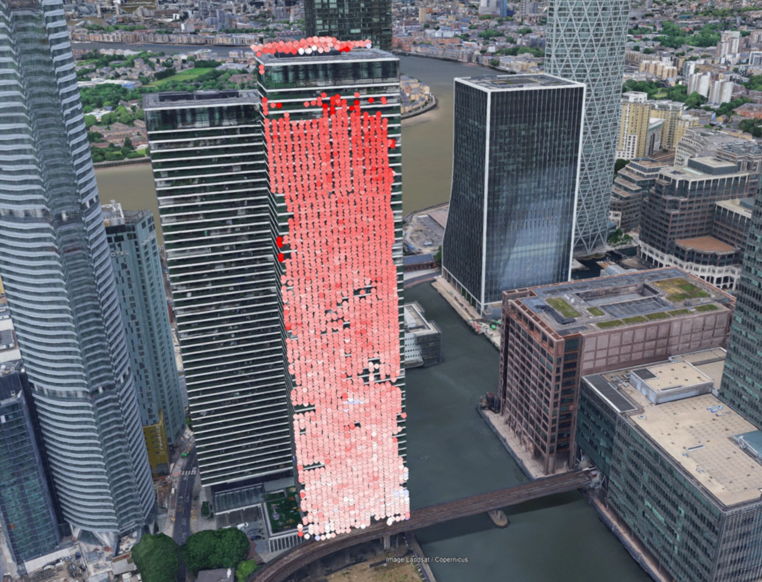
High-rise corridor with per-building displacement overlay
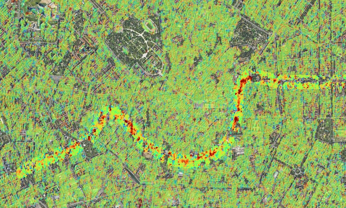
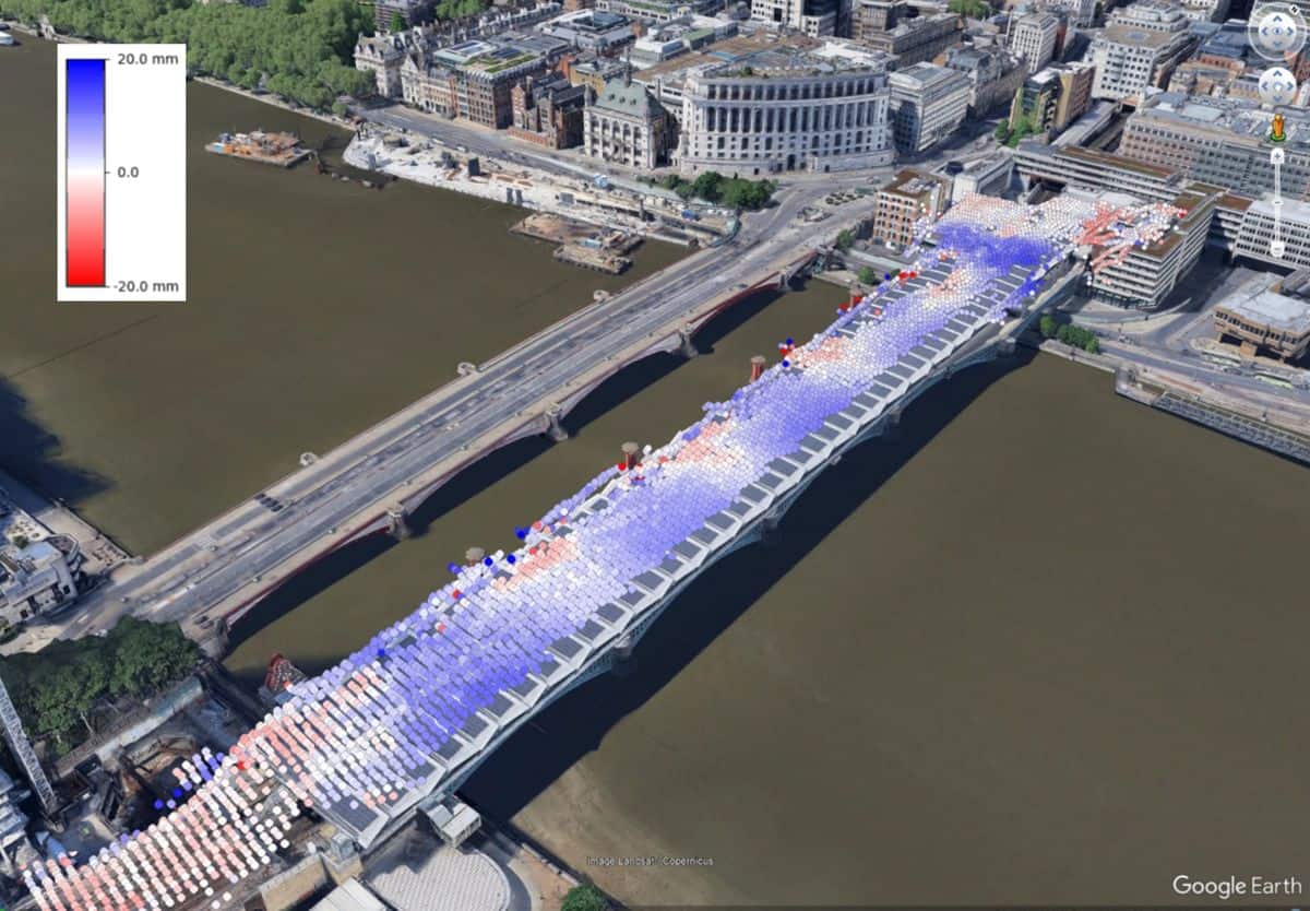
UrbanSAR surface deformation mapped along a subway tunnel corridor

Underground Construction

The problem
Tunnelling and deep excavation transfer stress to the surface, but regulatory baselines and pre-construction conditions are often undocumented before works commence.
Value Delivered
Pre-, during-, and post-construction monitoring using satellite archive data establishes baselines before works commence.

Rail & Transit

The problem
Inspections and instrumentation deployments along rail corridors are typically restricted to the tracks themselves, understanding displacement patterns beyond the immediate right-of-way remains challenging, particularly in urban settings where access rights are limited.
Value Delivered
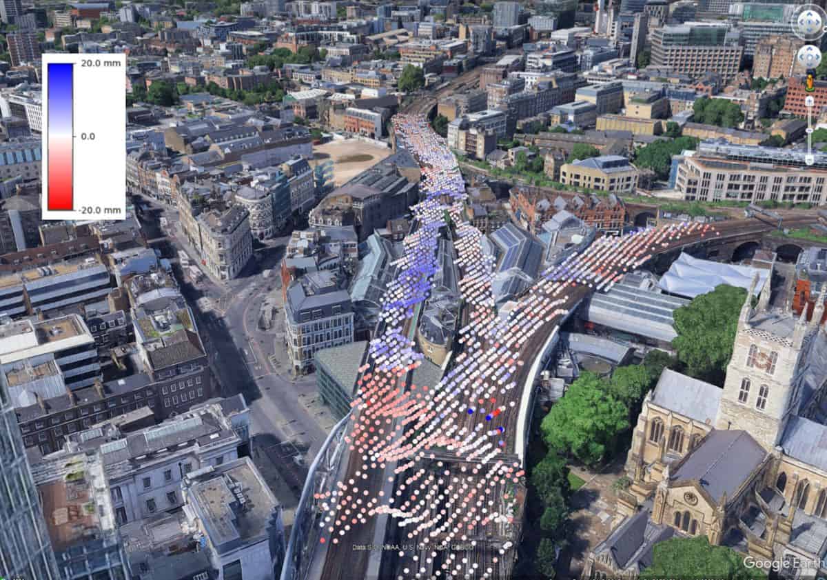
Satellite data is continuously acquired over cities regardless of land ownership, meaning InSAR data can provide important information beyond the tracks.
UrbanSAR displacement measurements along an urban rail corridor

Engineering & Liability

The problem
When displacement damages nearby property, disputes over cause and liability are difficult to resolve without objective, independent and historical evidence.
Value Delivered
Satellite-derived monitoring evidence supports compliance reporting and, where required, defends against or substantiates displacement liability claims.

Insurance & Risk

The problem
Underwriters price displacement risk with limited visibility into ground conditions, and claims assessment lacks consistent, corridor-wide evidence.
Value Delivered
City-scale monitoring supports claims assessment, evidence-based underwriting, and ground-condition differentiation for risk pricing, enabling the emerging category of displacement-linked insurance products.
UrbanSAR structural lean and settlement pattern analysis across a built-up site
Case Study · Toronto, Canada

Detecting movement beneath Toronto's towers

In Toronto's Yonge and Eglinton corridor, one of Canada's most active construction zones, UrbanSAR detected movement of up to 30 millimetres at the upper floors of newly built towers, the levels above where ground-based monitoring is typically focused.

An important signal UrbanSAR can detect is structural lean, which transfers stress to adjacent buildings, and maps settlement patterns to ensure existing foundations are not being undermined by nearby construction.

Historical satellite radar data has also tracked ground displacement across the full M4 subway tunnel corridor in Milan, detecting movement at millimetre accuracy directly relating to tunnel boring.
Read the article
New construction within the Greater Toronto Area, with UrbanSAR displacement values derived from satellite imagery
New construction within the Greater Toronto Area, with UrbanSAR displacement values derived from satellite imagery.
Technical FAQ

How UrbanSAR works, in detail

The questions engineering, insurance, and regulatory teams ask first.
UrbanSAR uses repeat-pass satellite radar, so measurements refresh with each overpass of the target city rather than in real time. New displacement readings are added up to every 6 days, building a continuous time series across successive passes.
Two proprietary steps supplement CATALYST's InSAR workflow to drive accuracy in urban environments. Building correction removes signal distortion and point-location assignment attributes each measurement to its true source.
UrbanSAR is sensor-agnostic and can be applied to any urban area globally. Supported sensors include, but are not limited to: Sentinel-1, TerraSAR-X, COSMO-SkyMed, RADARSAT-2 and NISAR.
In dense urban areas, tall buildings block lines of sight and standard processing mis-assigns radar reflections, causing errors and data gaps. UrbanSAR's point-location assignment corrects the 3D position of each point and preserves measurements standard processing would discard. Radar shadow, caused by buildings blocking the line of sight, can be addressed by using multiple lines of sight.
Outputs are analysis-ready and compatible with existing GIS and reporting workflows, supporting regulatory submissions and liability documentation.
Yes. Satellite archives enable historical look-back, so pre-construction baselines and pre-event conditions can be reconstructed without having planned monitoring in advance, which matters for compliance baselines and retrospective claims.
See what is already moving
Show a construction firm what was moving before they broke ground, an insurer the true extent of the risk they were underwriting, and a city authority the consequences of densification they approved.
  • Available now as a service, for any urban area globally
  • Multi-sensor radar at millimetre accuracy
  • Historical baselines from satellite archives
Request a briefing
Tell us about your site and our team will follow up.

"*" indicates required fields

Your Name*
We'll email your demo link here.
Join our newsletter?
This field is hidden when viewing the form

Hidden Fields

Fields that are used to capture dynamic parameters for tracking and marketing purposes.

envelopephone-handsetcrosscross-circle