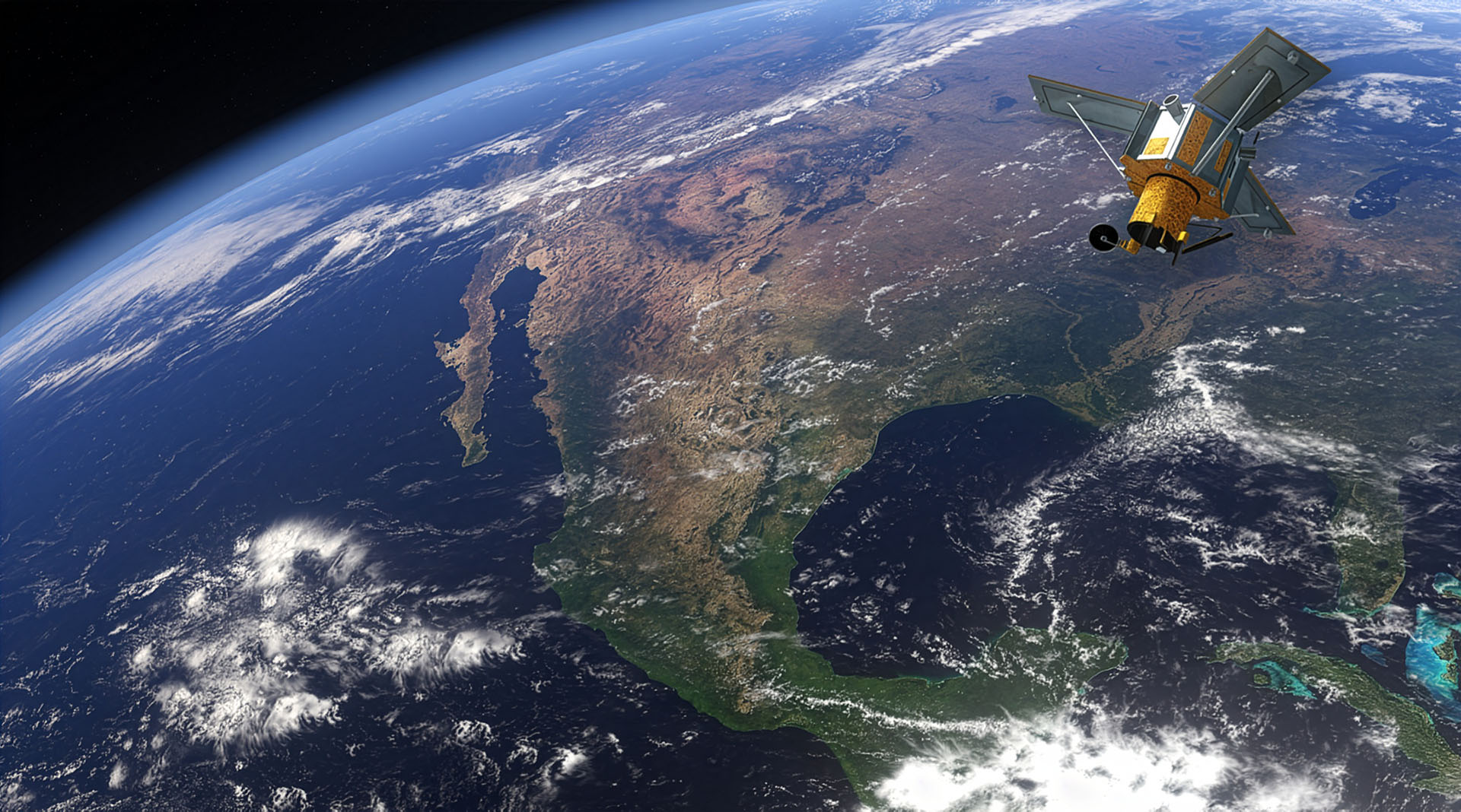
Geospatial Intelligence at the Speed of Decision
Satellite Imaging For Government and Defence
Precise Data, Fast Decision
Exceptional aerial image analytics and geospatial intelligence
Designed specifically for government and defence sectors
UK-based hub with dedicated UK-based staff
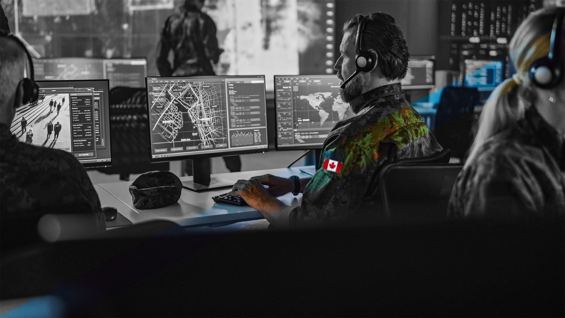
One Integrated Government and Defence Platform
Get more information on CATALYST Capabilities
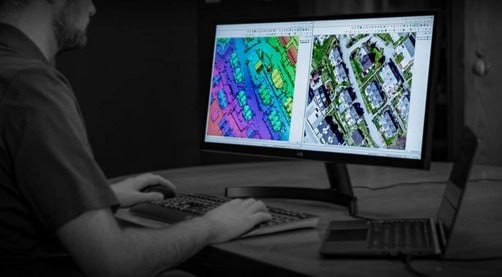
CATALYST government and defence capabilities gives you access to modular technology to fully leverage satellite and aerial imaging intelligence at scale.
With our solutions mission critical requirements can be addressed efficiently to shorten the Task, Collected, Process, Exploit and Disseminate (TCPED) cycle, make informed decisions, facilitate interoperability, and exceed mission requirements.
From automated alerts detected via the on-satellite technology to accurate geospatial maps built via industrial-scale image processing, you have the information you need when you need it. Move forward decisively, armed with the best possible intelligence.
CATALYST Edge
- In-orbit AI-driven vessel and object detection
- Receive alerts before imagery is delivered
- Sensor-to-decision timeline in under a minute
- Precise geometric correction on all bands in seconds
- Reduced downlink bandwidth requirements
- Automated tip-and-cue tasking triggers
CATALYST Insights - Horizon
- Persistent monitoring and change detection
- Priority alerting to movements and anomalies
- Actionable activity-based intelligence (ABI)
- Ship detection, classification, and track history
- Wildfire mapping and hotspot detection
- SAR and multispectral data fusion
CATALYST Enterprise
- Industrial-scale geospatial image processing
- High quality orthorectification and mosaicking
- MGCP & feature extraction workflows
- Automated QA/QC production pipelines
- Air-gapped and secure cloud deployment
- NGA, NITF & NATO compatible outputs
Built for missions that demand certainty
CATALYST delivers proven analytical intelligence for challenges faced by government and defence
Schedule a briefingMaritime Domain Awareness and Interdiction Support
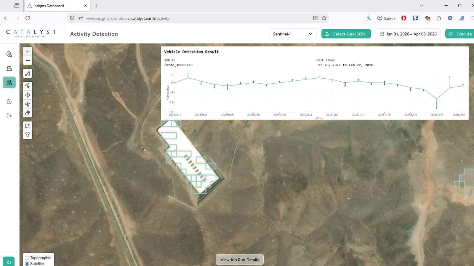
Battlespace Awareness and Activity-Based Intelligence
Emergency Response and Public Safety Coordination
Wildfire Detection, Monitoring & Planning Support
Baseline Mapping and Coalition Geospatial Production
Maritime Domain Awareness and Interdiction Support
Real Mission Implementation
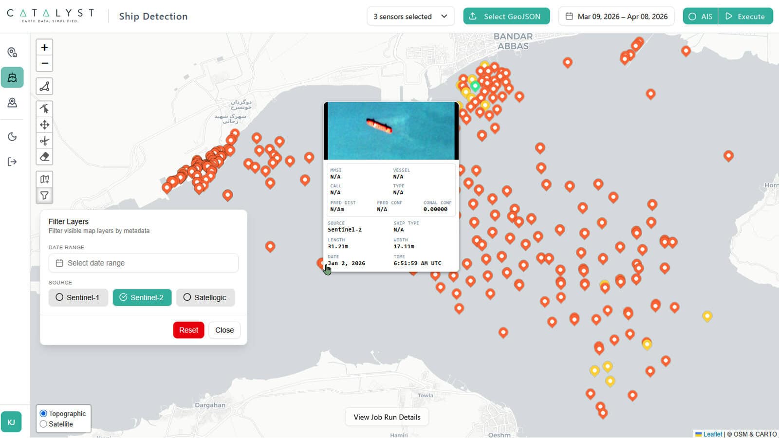
Current maritime intelligence solutions, such as AIS data, RF signals, airborne and maritime patrol, are ill-equipped to adequately monitor vast oceans. The solution is satellite technology. CATALYST delivers near-real-time situational intelligence consistently. Accurately maintain maritime domain awareness with on-satellite processing and AI-powered vessel detection. Within seconds of data being collected, actionable intelligence is sent directly to you.
Key Operational Capabilities
-
Low-latency detection: CATALYST efficiently processes imagery on-satellite. Vessel detection alerts are instantly communicated, preserving critical intercept windows.
-
Ship detection & classification: AI-driven feature extraction accurately identifies vessels by type, heading, speed estimate, and activity pattern.
-
Tip and cue: When a satellite detects an event it automatically triggers another higher-resolution satellite to collect more detailed imagery. It can also dispatch alerts to patrol aircraft and surface vessels for physical interdiction.
-
Dark vessel identification: Cross-correlation of AIS transponder data against satellite-detected vessel positions automatically flags non-broadcasting or AIS-spoofing targets.
CATALYST Solutions
Battlespace Awareness and Activity-Based Intelligence
Real Mission Implementation
The foundation of effective battlespace awareness is accurate, consistent data derived from processed and freshly collected imagery. CATALYST persistently monitors the battlespace by integrating the multi-source imagery, then processes the time series to measure change and determine the pattern of life. Analyst interpretations and decisions are better supported, workload is streamlined, and the decision cycle can be accelerated.
Key Operational Capabilities
-
Activity-based intelligence: CATALYST detects changes in vehicle counts, construction activity, force buildup, and logistics tempo across enemy positions to identify readiness and intent.
-
Temporal change detection: Automated comparison of current imagery against a geospatial baseline generates priority alerts for analysts, flagging anomalous activity without manual triage.
-
Multi-source fusion:Combining SAR, multispectral, and thermal imagery provides all-weather, day-and-night monitoring of high-value targets regardless of cloud cover.
-
Order of battle support: Feature extraction identifies and tracks military equipment, hardened positions, logistics nodes, and command infrastructure across large areas of interest.
CATALYST Solutions
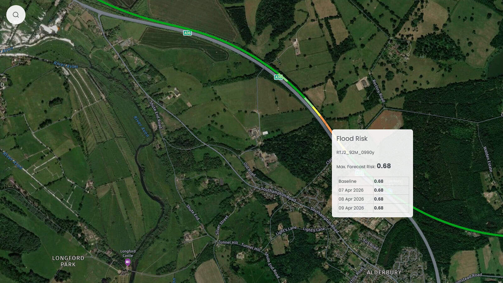
Emergency Response and Public Safety Coordination
Real Mission Implementation
In a natural disaster event or a mass casualty incident, responders need current, reliable data urgently. Emergency situations change quickly thus requiring the need for up to date imagery ideally delivered within minutes of collection. CATALYST compresses the timeline from satellite collect to comprehensive situational awareness data. This actionable intelligence enables coordinated responses across multiagency teams and interoperable collaboration.
Key Operational Capabilities
-
Near-real-time situation reports: Automated satellite-derived damage assessments, flood extents, and access route analysis delivered within minutes of data reception to emergency operations centres.
-
Before/after change detection: CATALYST Horizon's change detection engine rapidly identifies structural damage, displaced populations, and blocked infrastructure to prioritise resource allocation.
-
Multi-agency data sharing: Data is presented in standardised formats, including GeoTIFF, KMZ, shapefiles, and OGC web services, to support seamless dissemination and interpretation across emergency response departments.
- Aerial imagery integration: CATALYST Enterprise processes aerial survey data from manned and unmanned platforms to complement satellite coverage during the critical first 72 hours of an emergency incident, targeting areas where responders can maximise results.
CATALYST Solutions
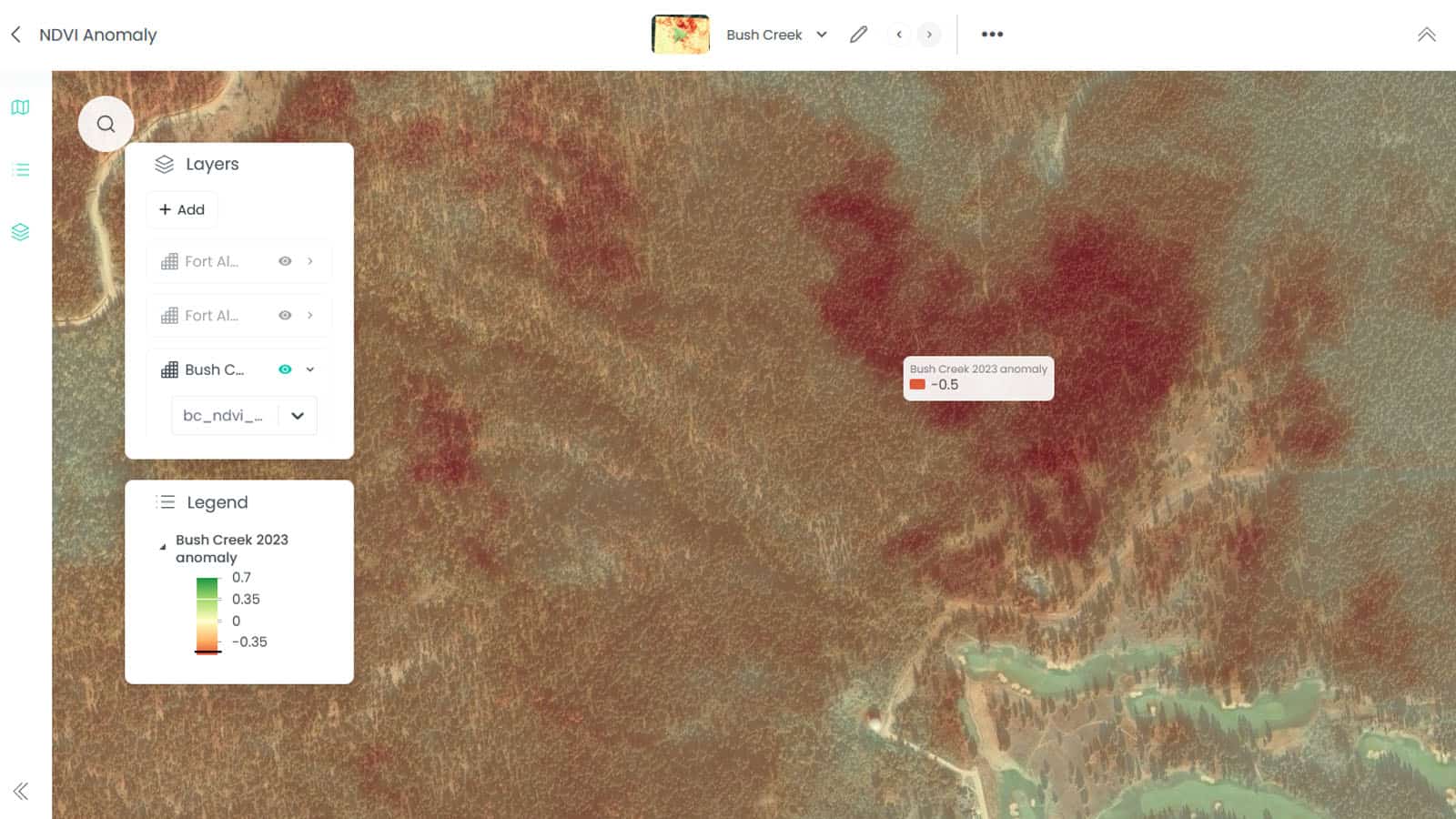
Wildfire Detection, Monitoring & Planning Support
Real Mission Implementation
Fire perimeters are unpredictable and can expand over kilometres in hours. Saving lives and property depends on effective deployment of resources. To successfully detect fires, plan for containment, prepare for evacuation, and coordinate emergency teams decision makers need precisely accurate data. CATALYST consistently delivers automated fire analytics from satellite and aerial sources in near-real-time.
Key Operational Capabilities
-
Active hotspot detection: Thermal and Short-Wave Infrared Satellite Imagery band analysis automatically identifies fire hotspots and active perimeter segments within minutes of satellite overpasses. Reliable automations mean no manual analyst triage is required.
-
Perimeter mapping & progression tracking: Time-series change detection monitors fire growth, producing GIS-ready perimeter polygons for planning purposes and resource allocation models.
-
Near-real-time aerial integration: CATALYST Enterprise processes infrared and thermal sensor feeds from fixed-wing and helicopter platforms to supplement satellite products during active fire suppression operations.
- Burn severity assessment: Post-fire multispectral analysis (dNBR, RdNBR) supports forest recovery planning, erosion risk modelling, and insurance damage estimation.
CATALYST Solutions
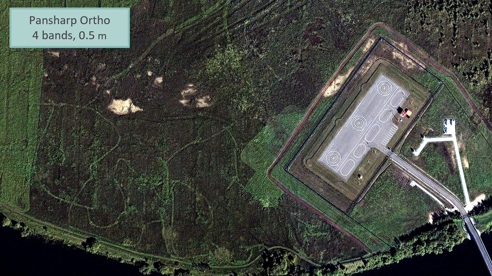
Baseline Mapping and Coalition Geospatial Production
Real Mission Implementation
Coalition warfare preparedness, contingency planning, and joint operations relies on geospatial baseline mapping. CATALYST Enterprise is purpose-built for large-scale data capture and processing. Baseline and geospatial mapping is compliant across multinational standards. This supports interoperable collaboration and allows defence mapping agencies to produce and sustain national production quotas.
Key Operational Capabilities
-
MGCP compliance: Feature extraction and attribution workflows aligned with the Multinational Geospatial Co-Production Program (MGCP) Technical Reference Document (TRD v4), producing cell-based topographic data to NSG standards.
-
High-volume production: Automated orthorectification, mosaicking, and QA/QC pipelines allow small production teams to sustain large-area mapping quotas across distributed multi-site organisations.
-
Coalition interoperability: As standard, imaging, data, and metadata formats are compatible with NGA, NATO Geospatial Group (NGG), and allied national mapping agency dissemination requirements.
- Classified network deployment: CATALYST Enterprise supports air-gapped classified environments, including JWICS, SIPRNet, and equivalent coalition security departments.
CATALYST Solutions
Geospatial imaging and data for the military
Designed specifically for branches of the military, the CATALYST platform quickly delivers the vital imaging and data analysts need.
Our Government and Defence Team works directly with program managers, contracting officers, and technical leads to align CATALYST capabilities with your requirements.
See the technology for yourself.
Schedule a briefing hereUsing satellite data to work with allied forces
The Multinational Geospatial Co-Production Program (MGCP)
CATALYST is the preferred platform for the MGCP. NATO launched the MGCP initiative to produce accurate geospatial maps of the entire land surface of the Earth. 40 nations are working together to deliver and maintain a consistent, high-resolution topographic dataset.
Participating defence mapping agencies use CATALYST to gather, process, and share finished data with other agencies. This collaboration reduces duplication, increases efficiency, and ensures allied forces operate from a common geospatial baseline. CATALYST delivers the throughput, standards compliance, and QA automation required to ensure each national production quota can be achieved, even across complex, large-volume mapping programs.
See the technology for yourself.
Schedule a briefing hereSee the technology for yourself.
Tell us your requirements and expectations and our Government and Defence team will demonstrate our exceptional imaging and data solutions.