Catalyst.earth Logo
Catalyst.earth Logo

Training

Leverage your investment to its full potential

Self-Paced Training

CATALYST Professional Modules
The following CATALYST Professional modules were developed as part of a structured training series that provides an overview of the platform and its core workflows. Each module can be completed independently or combined to support specific end-user workflows and use cases.

The lessons are built around practical, day-to-day tasks and provide step-by-step guidance for using key CATALYST Professional applications, tools, and features.
CATALYST Image Classification Module image
CATALYST Image Classification Module
This module focuses on image classification methods available in the core CATALYST applications within the CATALYST Professional suite.

It also introduces key remote sensing concepts through a series of modules and lessons covering supervised classification, unsupervised classification, post-classification processes, and Object-Based Image Analysis (OBIA).
Download PDF
CATALYST Urban Change Detection Module
This module introduces change detection workflows in CATALYST Professional for identifying and analyzing land-cover changes over time.

Using before-and-after imagery, the workflow prepares segments and classifies land cover data to detect changes such as urban expansion.

The module also demonstrates how to quantify land-use change through raster comparison and statistical analysis.
Download PDF
CATALYST Mosaicking Module
This module introduces mosaicking in remote sensing using CATALYST Professional. Mosaicking combines multiple overlapping satellite or aerial images into a single seamless, geospatially consistent dataset through geometric correction and radiometric normalization.

This module covers the benefits of mosaicked imagery, common applications, and the workflows in CATALYST Professional for creating, preparing, editing, and generating mosaics.
Download PDF
Learn CATALYST at your own pace, on your own time, and on any device.
Antisana image
Advanced SAR Training with CATALYST Professional
Theory and application practices for InSAR, polarimetry and compact polarimetry.
Register
Geospatial image of The Netherlands
Geospatial Image Visualization with CATALYST Professional
Learn how to view geospatial imagery acquired from Earth observation satellites.
Register
Image of SAR objects
Basic Raster and Vector Operations
Manipulate your optical satellite imagery and generate information from EO imagery.
Register
Aerial image of a residential area
Creating Seamless Mosaics From Air Photos
Working with software to create ortho mosaics can provide flexibility and significant time savings.
Register
Image of an old, historical aerial image
Historical Airphoto Processing (HAP) with CATALYST
Learn how to work with scanned historical air photos in the Historical Airphoto Processing (HAP) module of CATALYST Professional.
Register

CATALYST Professional Training Courses

Whether you are new to remote sensing or looking to advance your geospatial expertise, our training courses provide practical instruction ranging from foundational concepts to advanced remote sensing workflows.
CATALYST 1
CATALYST 2
CATALYST ORTHOENGINE
SAR PROCESSING
Course Description

Designed for both new and experienced geospatial professionals, this course introduces the fundamentals of working with raster data in CATALYST Professional. Participants will learn how to visualize, manage, and process geospatial datasets using core tools and workflows within the platform.

By the end of the course, participants will be comfortable using key tools within CATALYST Professional for everyday geospatial data processing tasks.

Topics Covered
  • CATALYST Focus
  • Raster Visualization
  • Geospatial Data Processing
  • Core Processing Workflows
Level

Introductory

Delivery Options

Training can be delivered online or in a classroom setting depending on your requirements. Contact us for additional details and scheduling options.

Course Description

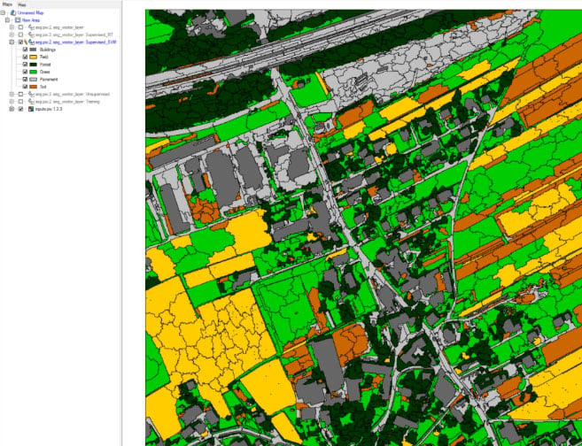
As a follow-up to CATALYST 1, this course expands on advanced data processing techniques within CATALYST Professional. Participants will explore workflows including multispectral image classification, atmospheric correction, spatial analysis, and thematic map creation.

The course also introduces the Modeler environment for visual scripting, workflow automation, and batch processing of geospatial data.

Topics Covered
  • Image Classification
  • Atmospheric Correction
  • Spatial Analysis
  • Thematic Map Creation
  • Workflow Automation with Modeler
Level

Introductory / Intermediate

Delivery Options

Training can be delivered online or in a classroom setting depending on your requirements. Contact us for additional details and scheduling options.

Course Description

Designed for both new and experienced users of remote sensing and digital photogrammetry software, this course introduces the core workflows within CATALYST OrthoEngine. Participants will learn how to set up projects, collect GCPs and tie points, perform orthorectification, and create image mosaics using both manual and automated workflows.

The course also introduces workflow automation and batch processing using Modeler components within CATALYST Professional.

Topics Covered
  • Orthorectification
  • DEM Extraction
  • Pan Sharpening
  • Mosaic Creation
  • Workflow Automation
Level

Intermediate

Delivery Options

Training can be delivered online or in a classroom setting depending on your requirements. Contact us for additional details and scheduling options.

Course Description

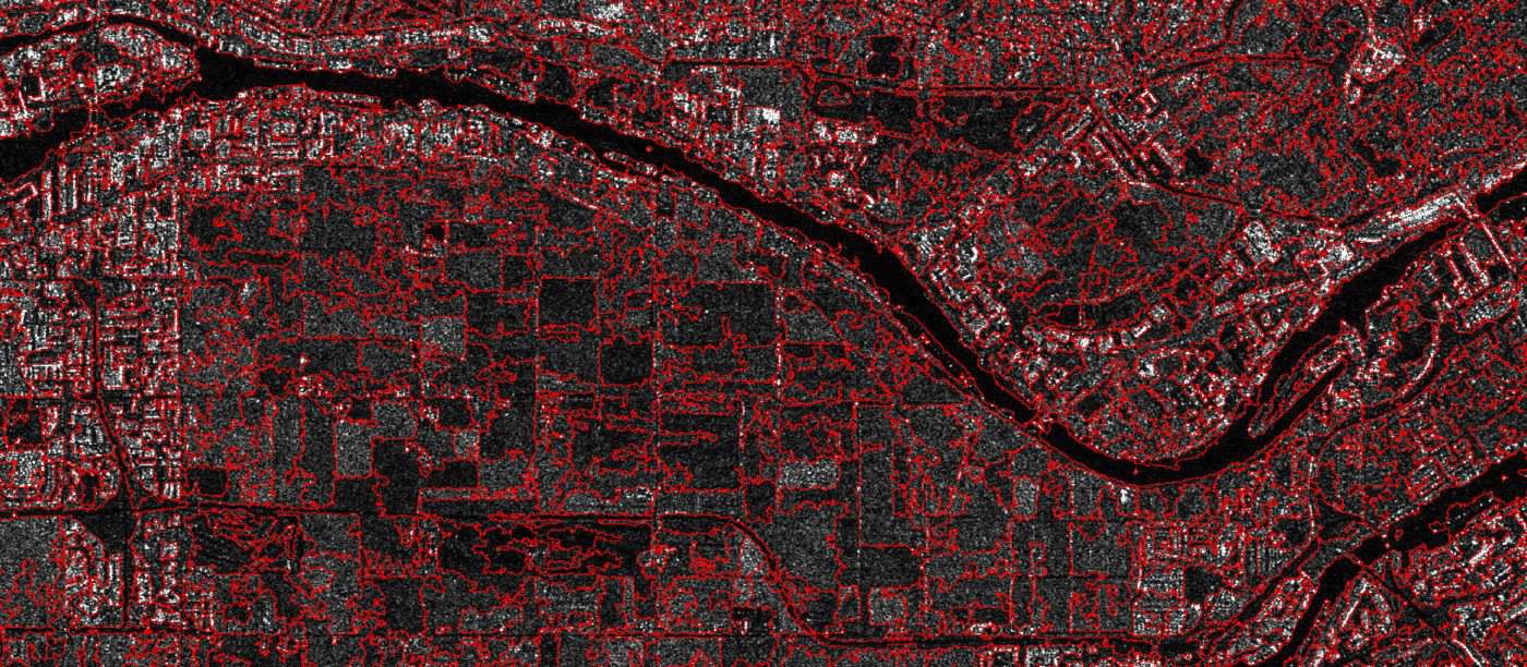
This advanced course explores data preparation, processing, and analysis techniques for working with Synthetic Aperture Radar (SAR) data in CATALYST Professional.

Participants will learn how to ingest, calibrate, visualize, and enhance SAR data using workflows within Focus. The course covers detected data processing, polarimetric decomposition, polarimetric discriminator analysis, and coherent change detection using single, dual, and polarimetric SAR datasets.

The course also introduces the SAR Polarimetry Target Analysis (SPTA) tool, including target definition, polarimetric property analysis, and interpretation of numerical and graphical outputs such as histograms and polarimetric response plots.

Topics Covered
  • SAR Data Calibration
  • Polarimetric Analysis
  • SAR Image Classification
  • Coherent Change Detection
  • SAR Polarimetry Target Analysis (SPTA)
Level

Advanced

Delivery Options

Training can be delivered online or in a classroom setting depending on your requirements. Contact us for additional details and scheduling options.

Our Delivery Formats

Instructor led, onsite or online, we have the right training format for any situation. Contact us to receive a free, no obligation quote regarding our training services.
Online
PCI continually invests in the latest training technology - an online training facility is available, which offers numerous advantages over conventional training courses. The instructor lead course content is exactly the same, with the added convenience of being offered online.
Find out More
Onsite
Receive expert instruction in the comfort of your own facility. Let a PCI Geomatics instructor bring their experience to you. Our instructors will assist you in the planning and development of specialized training programs designed to meet your specific objectives.
Find out More
At Our Facility
Travel to our facility (Gatineau, Canada - just outside downtown Ottawa) where you can receive expert instruction in PCI's facility. Our instructors will assist you in the planning and development of specialized training programs designed to meet your specific objectives.
Find out More
Customized
If you need in-depth training on specific topics, PCI Geomatics can provide custom consulting sessions with one of our specialized instructors. Working with your own data, our Training Department can create a customized training course, exploring the skills and tools you need to complete your geospatial projects with confidence.
Find out More
envelopephone-handsetcross