A grid is an array of regularly-spaced parallel and perpendicular lines arranged over an Area. Each cell is used as a reference point for determining locations or coordinates. For example, they can be used in conjunction with street indexes.
A graticule is drawn along latitude and longitude lines or a representation that relates points in an Area to locations on the ground.
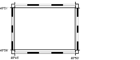
Georeferenced grids are linked to Area data. They can be used to locate and reference Map features with the Earth through georeferenced coordinate systems. Georeferenced grids are not always rectilinear. For example, latitude/longitude grids have curved grid lines, while UTM grids have both curved and straight lines.
The position of a grid is based on the position of a neatline or on an Area if a neatline is not set.
To add a grid to an area, see Creating a surround. You cannot create a grid in a rotated Area (Raster Up). For more information, see About rotated rasters.
To open the Grid Properties window, see Setting surround element properties.
The look of a grid (or graticule) is determined by its:
- General properties (see Changing grid pacing and proximity to neatline)
- Layout properties (see Changing the style and layout of the grid)
- Headings properties (see Changing the location and style of the grid headings)
- Label properties (see Changing the location and style of the grid labels)
- Position (see Setting the updating behavior)
- Quick Style (see Selecting an existing quick style)