Orthorectifying airphotos requires a digital elevation model (DEM) to correct geometry and relief-displacement. This requirement is central for airphoto orthorectification. The three general workflows for providing a DEM for airphoto orthorectification are described herein.
Workflow I
You have a DEM that is readily available for airphoto orthorectification. The only potential task you may need to complete is to create a DEM index file. For information on doing so, see Creating a DEM index file.

Workflow II
- Mass points
- Contours
- Break lines
- Building models
- Lake polygons
- Cliffs and valleys
- Bridges
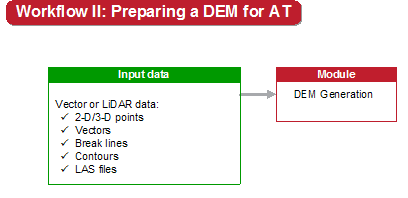
In CATALYST Enterprise, you can combine hundreds—even thousands—of vector-data files to create a high-accuracy raster digital surface model (DSM) or digital terrain model (DTM), depending on the content of the data.
CATALYST Enterprise also supports the American Society for Photogrammetry and Remote Sensing (ASPRS) Light Detection and Ranging (LiDAR) LAS file format version 1.0, and treats each LiDAR return number as a separate vector layer. If the LiDAR data contains surface-model points, the resulting raster DSM can be converted automatically to a DTM or edited manually with DEM Editing in CATALYST Professional Focus.
The prerequisite for this workflow is at least one of the aforementioned vector data types or a LiDAR LAS file.
For information on generating a DEM, see Generating a DEM.
Workflow III
You have a DEM extracted from stereo-image pairs for airphoto orthorectification.
The prerequisites for workflow 3 are a project with an adequate aerial-triangulation solution and sufficient overlap between the images.
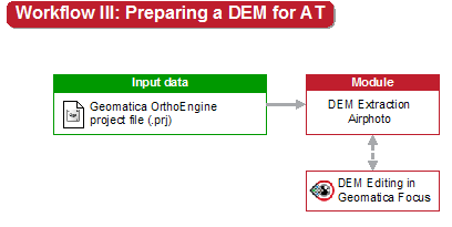
For information on extracting a DEM from stereo-image pairs, see Extracting a DEM from stereo-image pairs.