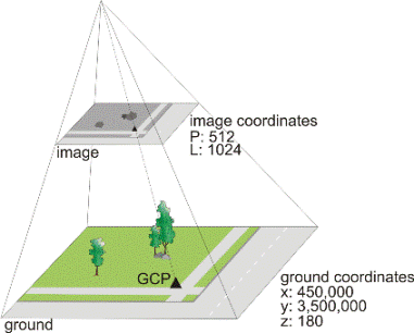
A ground control point (GCP) is feature that you can clearly identify in the raw image for which you have a known ground coordinate. Ground coordinates can come from a variety of sources such as the Global Positioning System (GPS), ground surveys, geocoded images, vectors, geographic information systems (GIS), topographic maps, chip databases, or by using photogrammetric processes to extend the number of GCPs in your images. A GCP determines the relationship between the raw image and the ground by associating the pixel (P) and line (L) image coordinates to the x, y, and z coordinates on the ground.