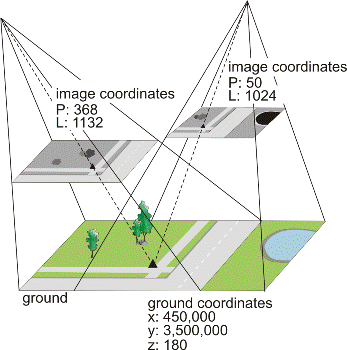
A stereo ground control point (GCP) is a cross between a regular GCP and a tie point. It is a feature with known ground coordinates that you can clearly identify in two or more images. They have the same Point ID, Easting and Northing coordinates and elevation value, but the pixel and line location is different in each image.
Therefore, a stereo GCP not only determines the relationship between the raw images and the ground, like a GCP, but also identifies how the images in your project relate to each other, like a tie point. The result is a stronger math model since the stereo GCPs add redundancy and are weighted more heavily in the calculation of the math model.
Figure 1. Example of a stereo GCP