If necessary, you can change the unit for the coordinates of the cursor poition.
Figure 1. Selecting the cursor-position unit
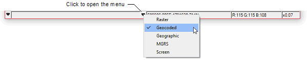
The available units are as follows:
- Raster:: Display the coordinates in image pixels and lines measured from the upper-left corner of the image.
- Geocoded:: Display the coordinates in easting and northing values.
- Geographic:: Display the coordinates in longitude and latitude values.
- MGRS:: Display the coordinates using the Military Grid Reference System.
- Screen:: Display the coordinates in screen pixels measured from the upper-left corner of the viewer.
To change the unit for the cursor-position coordinates
- On the status bar, click the rightmost down arrow.
-
On the menu that appears, click the unit you want:
A check mark is added beside the unit you selected.