INSTOPO
Flat-Earth and topographic corrections to interferograms
Description
INSTOPO adjusts the phase of a raw interferogram to compensate for flat-Earth and topographic effects.
Parameters
instopo(fili, dbic, filedem, filo)
| Name |
Type |
Caption |
Length |
Value range |
| FILI* |
str |
Database input file name |
1 - |
|
| DBIC |
List[int] |
Database input channel list |
0 - |
1 - |
| FILEDEM |
str |
Database DEM file name |
0 - |
|
| FILO* |
str |
Database output file name |
1 - |
|
* Required parameter
Parameter descriptions
FILI
The name of the input interferogram created with the INSRAW algorithm.
DBIC
The layer or layers from the input interferogram to process. The default is to process only the first channel.
FILEDEM
The name of the file containing the digital elevation model (DEM). The DEM information must be in meters and stored in the first channel of the file.
FILO
The name of the file to which to write the phase-corrected interferograms. The file name you specify must not exist already.
Return Value
Returns: Program execution status
Type:
PCI_INT
The return value is 0.
This function returns only if it executes successfully; otherwise, it throws an exception.
|
Details
INSTOPO models the orbits of the reference and dependent files to calculate the required adjustment of the interferometric phase for systematic (flat-Earth) effects. When you specify a DEM, variations in interferometric phase caused by topography are corrected. The systematic flat-Earth and optional topographic corrections are adjusted for the nominal processing elevation, in meters, provided by the NominalLocation_Height metadata tag. If the nominal processing elevation is not available in the metadata, the surface of the ellipsoid is assumed.
The DEM elevations are resampled to the slant range of the reference file. For each slant-range pixel, the modified elevation, incident angle, and interferometric gradient are computed to calculate the flat-Earth and topographic-phase corrections. The NoData areas of the input file are not modified. If the DEM does not fully cover the area covered by the interferogram, the output for the nonoverlapping regions is processed as NoData.
If you do not specify a DEM, you can use the output to generate one. By doing so, the InSARContent metadata tag is set to TopographicInterferogram. When you specify a DEM, you can use the output to generate a deformation map. By doing so, the InSARContent metadata tag is set to DeformationInterferogram. The InSARContent metadata tag is read by the INSUNWRAP algorithm to determine the type of processing to apply.
If there are any residual fringes due to orbital error, you can correct them by running the INSADJUST algorithm.
Examples
The following example corrects a single-channel interferogram for flat-Earth effects, but does not remove topographic fringes. The output interferogram can be unwrapped by running the INSUNWRAP algorithm to generate a DEM.
from pci.instopo import instopo

fili    =  r"C:\MyProject\Single_channel_interferogram.pix"
dbic    =  []
filedem =  ""
filo    =  r"C:\MyProject\Topographic_interferogram.pix"

instopo(fili, dbic, filedem, filo)
The following example corrects a single-channel interferogram for flat-Earth effects and topographic fringes. The output interferogram can be unwrapped by running the INSUNWRAP algorithm to generate a deformation map.
from pci.instopo import instopo

fili    =  r"C:\MyProject\Single_channel_interferogram.pix"
dbic    =  []
filedem =  r"C:\MyProject\DEM.tiff"
filo    =  r"C:\MyProject\Deformation_interferogram.pix"

instopo(fili, dbic, filedem, filo)
The following example removes flat-Earth and topographic fringes from a multi-channel interferogram.
from pci.instopo import instopo

fili    =  r"C:\MyProject\Multi_channel_interferogram.pix"
dbic    =  [1,2,3,4]
filedem =  r"C:\MyProject\DEM.tiff"
filo    =  r"C:\MyProject\Multi_Channel_Deformation_interferogram.pix"

instopo(fili, dbic, filedem, filo)
Algorithm
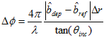
The phase adjustment of each point is computed by the following formula, where \u00ce\u00bb is the wavelength, \u00ce\u201dr is the reference slant range sample size, \u00ce\u00b8
inc is the reference incident angle to the point,

is the unit vector pointing from the pixel's location on the earth's surface to the reference and dependent satellite positions, and

is the interferometric gradient vector:
Acknowledgements
The PCI Interferometric SAR (InSAR) project was funded in part by the Canadian Space Agency under the Earth Observation Application Development Program (EOADP) contract (9F043-130644/006/MTB), Application Development for Environmental Monitoring and Remediation.
© PCI Geomatics Enterprises, Inc.®,
2024. All rights reserved.