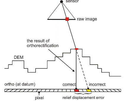
Orthorectification is the process of using a rigorous math model and a digital elevation model (DEM) to correct distortions in raw images. The rigorous math models, such as the Aerial Photography or Satellite Orbital math models, provide a method to calculate the position and orientation of the sensor at the time when the image was taken. The DEM is a raster of terrain elevations. The quality of the orthorectified image is directly related to the quality of the rigorous math model and the DEM. A poorly computed math model, an inaccurate DEM, or a DEM incorrectly georeferenced to the math model will cause errors in the orthorectified images.