The rapid deployment of SmallSats, super constellations and virtual ground receiving stations is creating new competition and market pressures. This is driving down prices and increasing customer expectations around quality, order latency and customer experience.
PROCESSING SOLUTIONS FOR SATELLITE IMAGERY
DELIVER BETTER QUALITY
Superior Positional and Radiometric Accuracy
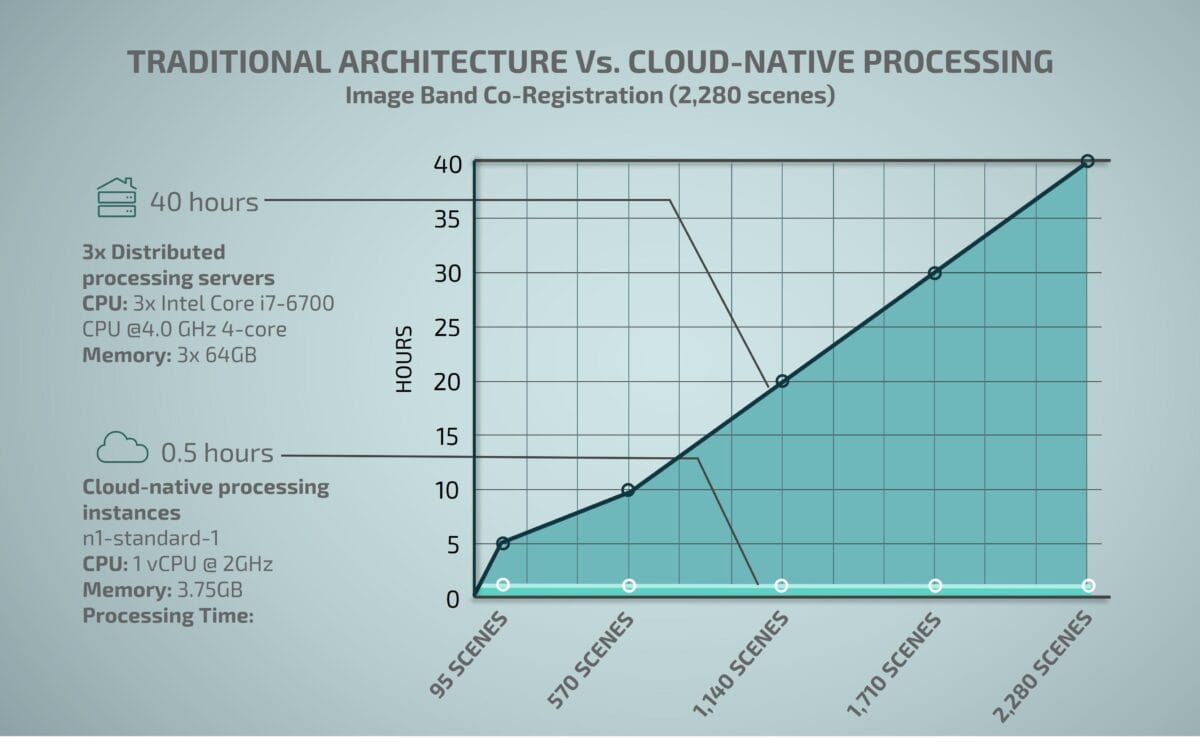
Proven 1/10th pixel accuracy and 0.91 Mean R2 radiometric accuracy (surface reflectance (NBAR))
Our competitive plans remove the traditional barriers of accessing professional software for processing and analyzing earth observation imagery and is trusted by thousands of geospatial professionals from around the world.
To provide the best experiences, we use technologies like cookies to store and/or access device information. Consenting to these technologies will allow us to process data such as browsing behaviour or unique IDs on this site. Not consenting or withdrawing consent, may adversely affect certain features and functions.
Functional
Always active
The technical storage or access is strictly necessary for the legitimate purpose of enabling the use of a specific service explicitly requested by the subscriber or user, or for the sole purpose of carrying out the transmission of a communication over an electronic communications network.
Preferences
The technical storage or access is necessary for the legitimate purpose of storing preferences that are not requested by the subscriber or user.
Statistics
The technical storage or access that is used exclusively for statistical purposes.The technical storage or access that is used exclusively for anonymous statistical purposes. Without a subpoena, voluntary compliance on the part of your Internet Service Provider, or additional records from a third party, information stored or retrieved for this purpose alone cannot usually be used to identify you.
Marketing
The technical storage or access is required to create user profiles to send advertising, or to track the user on a website or across several websites for similar marketing purposes.
 Speak To A Specialist