INSINFO
Generate report of interferometric parameters
Description
INSINFO generates a text file of the sensor and interferometric parameters for the configurations of the reference and dependent files you specify.
Parameters
insinfo(filref, mfile, tfile)
| Name |
Type |
Caption |
Length |
Value range |
| FILREF |
str |
Database reference file name |
0 - |
|
| MFILE * |
str |
Input file name, folder, or text file |
1 - |
|
| TFILE |
str |
Text file name |
0 - |
|
* Required parameter
Parameter descriptions
FILREF
The name of the file to use as the reference data set. The file can be a data set that has been imported into PCIDSK (
.pix) format by SARINGEST or the key-file name of any GDB-supported single-look complex (SLC) data set in its distribution format.
Leave blank to output comparison of all MFILE files. Output will temporally order files then step through each as a FILREF for comparison to all files with a later date/time.
MFILE
The name of a folder, data set, or text file that contains the dependent SLC data sets to process. For more information about using MFILE, including the requirements for a valid file, see
Using an MFILE with a CATALYST Professional algorithm.
TFILE
The name of the text file to which to write the interferometric parameters. The output file contains reference-sensor information followed by sensor and baseline information for each dependent file specified.
Details
INSINFO extracts the following information from the reference-file metadata:
- Acquisition Date and Time
- Center of Image Location
- Wavelength (meters)
- Beam Mode
- Available Polarization(s)
- Look Direction
- Pass Direction
- Near Incident Angle (degrees)
- Far Incident Angle (degrees)
- Sample Scale in Azimuth and Line (meters)
- First Pixel Slant Range (meters)
- Last Pixel Slant Range (meters)
- Pulse Repetition Frequency (hertz)
- Processing Elevation (meters)
- Critical Baseline (meters)
- Nominal ECEF Satellite Position (meters)
The critical-baseline distance is computed by using the midpoint of the reference image. The critical baseline represents the maximum allowable baseline distance (separation between antennae) for interferometric processing. The reported nominal Earth-centered, Earth-fixed (ECEF) satellite position is calculated at the midpoint of the reference image and represents the distance along the x, y, and z axis from the center of the Earth.
For each dependent image, the corresponding sensor information is extracted from the metadata for comparison. The time difference is calculated as the elapsed time of acquisition between the dependent and reference data. The percentage of image overlap is derived from the geocoding information contained in the reference and dependent files. The ambiguity height represents the change in elevation corresponding to one interferometric cycle.
The reference and dependent orbits are modeled from the state vectors to determine the baseline distances at the times associated with the scan lines of the first, middle, and last reference. The perpendicular baseline is positive when the incident angle of the reference file is greater than the incident angle of the dependent.
The following interferometric parameters are also provided for each dependent data set:
- Time Difference (dd:hh:mm:ss.xxx)
- Percentage Image Overlap (%)
- Ambiguity Height (m)
- First Line Baseline Distance (m)
- First Line Parallel Baseline Distance (m)
- First Line Perpendicular Baseline Distance (m)
- Nominal Pixels Per Fringe
- Middle Line Baseline Distance (m)
- Middle Line Parallel Baseline Distance (m)
- Middle Line Perpendicular Baseline Distance (m)
- Last Line Baseline Distance (m)
- Last Line Parallel Baseline Distance (m)
- Last Line Perpendicular Baseline Distance (m)
Examples
Generate a report file by using a single reference file and a single dependent file.
from pci.insinfo import insinfo

filref = "Reference_File.pix"
mfile  = "Dependent_Files.pix"
tfile  = "Interferometric_Report_SinglePair.txt"

insinfo(filref, mfile, tfile)
Generate a report file by using the single reference file and the multiple dependent files listed in the text file.
from pci.insinfo import insinfo

filref = "Reference_File.pix"
mfile  = "List_Of_Dependent_files.txt"
tfile  = "Interferometric_Report_Multiple_Dependent.txt"

insinfo(filref, mfile, tfile)
Generate a report file by using the single reference file and the dependent PCIDSK files in the folder specified.
from pci.insinfo import insinfo

filref = "Reference_File.pix"
mfile  = "Dependent_Directory\*.pix"
tfile  = "Interferometric_Report_Dependent_Directory.txt"

insinfo(filref, mfile, tfile)
Algorithm
The critical-baseline distance (m) is computed as follows, where R is the (mid-point) slant range, λ is the radar wavelength, ρ
r is the range resolution and θ
inc is the (midpoint) incident angle:
The parallel  , perpendicular
  and baseline
  distances are defined by the satellite positions and represent the lengths of their respective vectors. The sign of the perpendicular baseline is positive when the incident angle of the reference data set is greater than the incident angle of the dependent data set.
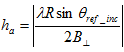
The ambiguity height represents the change in elevation for one interferometric cycle, as computed by the following:
Acknowledgements
The PCI Interferometric SAR (InSAR) project was funded in part by the Canadian Space Agency under the Earth Observation Application Development Program (EOADP) contract (9F043-130644/006/MTB), Application Development for Environmental Monitoring and Remediation.
© PCI Geomatics Enterprises, Inc.®,
2026. All rights reserved.