Parameter descriptions
Fili: Raw interferogram
The list of channel numbers of the input interferogram to process.
InputDEM: DEM elevation layer
The digital elevation model (DEM), which you can specify as an option. The DEM information must be in meters.
Output: Output corrected interferogram
The name of the file to which to write the phase-corrected interferograms. The file name you specify must not exist already.
Details
INSTOPO models the orbits of the reference and dependent files to calculate the required adjustment of the interferometric phase for systematic (flat-Earth) effects. When you specify a DEM, variations in interferometric phase caused by topography are corrected. The systematic flat-Earth and optional topographic corrections are adjusted for the nominal processing elevation, in meters, provided by the NominalLocation_Height metadata tag. If the nominal processing elevation is not available in the metadata, the surface of the ellipsoid is assumed.
The DEM elevations are resampled to the slant range of the reference file. For each slant-range pixel, the modified elevation, incident angle, and interferometric gradient are computed to calculate the flat-Earth and topographic-phase corrections. The NoData areas of the input file are not modified. If the DEM does not fully cover the area covered by the interferogram, the output for the nonoverlapping regions is processed as NoData.
If you do not specify a DEM, you can use the output to generate one. By doing so, the InSARContent metadata tag is set to TopographicInterferogram. When you specify a DEM, you can use the output to generate a deformation map. By doing so, the InSARContent metadata tag is set to DeformationInterferogram. The InSARContent metadata tag is read by the INSUNWRAP algorithm to determine the type of processing to apply.
If there are any residual fringes due to orbital error, you can correct them by running the INSADJUST algorithm.
Algorithm
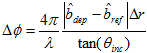
The phase adjustment of each point is computed by the following formula, where λ is the wavelength, Δr is the reference slant range sample size, θ
inc is the reference incident angle to the point,

is the unit vector pointing from the pixel's location on the earth's surface to the reference and dependent satellite positions, and

is the interferometric gradient vector: