You can create a digital elevation model (DEM) from stereo pairs of images, which are two or more images of the same area taken from different viewpoints. This method can be very useful for creating a DEM for inaccessible areas. You can obtain stereo pairs from aerial photographs, digital images, and these sensors: ASAR, ASTER, CARTOSAT, EROS, IRS, IKONOS, KOMPSAT-2, KOMPSAT-3, PRISM, SPOT, QUICKBIRD, RADARSAT, and WorldView.
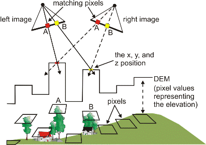
OrthoEngine uses image correlation to extract matching pixels in the two images and then uses the sensor geometry from the computed math model to calculate x, y, and z positions.
Figure 1. Creating a DEM from stereo pairs