Exterior orientation (EO) is the position and orientation of the camera when the image was taken. That is, it is the relationship between the ground and the image. EO represents a transformation from the ground coordinate system to the image coordinate system. Many photogrammetric cameras are equipped with an onboard Global Positioning System (GPS) and sometimes with an inertial navigation system (INS) or inertial measurement unit (IMU). These systems collect the EO directly on the plane.
In most projects, EO is computed from ground control points (GCP) and tie points (TP). Adding estimated or observed EO to your project reduces the number of GCPs that you need, helps to automate collection of TPs, and decreases the time needed to set up the project, because it provides an approximate location for the images.
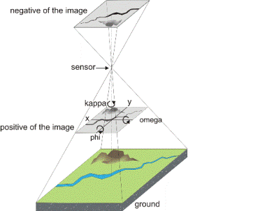
The position of the camera means the x, y, and z location of the camera's focal point measured in a right-handed mapping coordinate system. The orientation of the camera is given by omega (the rotation about the x-axis), phi (the rotation about the y-axis), and kappa (the rotation about the z-axis). The x, y, and z coordinates and the omega, phi, and kappa angles are referred to collectively as the six parameters of EO.
You can import the GPS/INS data (navigation solution) as direct observations of the EO. GPS/INS data from any sensor system (including POS/EO from Applanix) that uses omega, phi, and kappa is compatible with OrthoEngine. Use the GPS/INS data alone as user input, and accept them as correct, or use GCPs, TPS, or both to refine the GPS and INS results. If you have an existing triangulation solution for the project, you can import it as a known solution for the EO. By doing so, you can skip collecting GCPs and TPs.
GPS, IMU, and triangulation data are usually already calibrated to the orientation of the images, but, in some cases, may require kappa rotations. It is quite common for some formats, such as Albany and Pat-B, to have kappa values rotated due to different flight lines. You should rotate the kappa value according to the scanning direction. Kappa is the counter-clockwise angle required to rotate from map north to image north (up).
For example, a scanned image with north up should have kappa near 0 degrees, while an image with north right should have kappa near 90 degrees. If an image is scanned with north up and the input kappa value is about 90 degrees, you will need to rotate the kappa value by -90 degrees (90 degrees is equivalent to 100 gradients).